

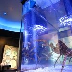
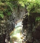
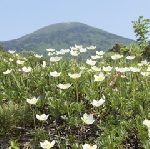
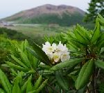
Tainoura – the coast of sea bream, is a shallow sea of 10 to 30 m. Sea breams form groups, which normally live in rocks and gravel at a depth of 30 to 150 m. This phenomenon has not been scientifically proven. The sea bream here is related to the birth of Nichiren (1222 – 1282), the founder of Nichiren sect.
The fish have been fed and protected by local people since the Kamakura period (1185 – 1333). Throughout the year, when you hit the side of a sightseeing boat and make a sound, the groups of sea breams will come near the surface of the water.
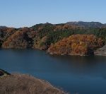
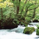
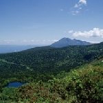
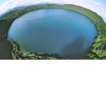
The steam explosion and pyroclastic flow of 3005 years ago, in the Jomon period (16,000 years ago – 3,000 years ago), caused a landslide, created a pot-shaped depression and a special view of Ahinoko Lake, with springing water. The lake is not a caldera, where rainwater has accumulated, and most of the water source is spring water from the bottom of the lake. Here is a reason for the myth – Lake Ashinoko used to be dominated by the big Dragon Gods (the god of water).
A pleasure boat connects Hakone Sekisho, Moto-Hakone, Lake Hijiri, and Hakone-en with regular routes. There is a regular line of Sightseeing Boats that connect Hakone no Sekisho, the restored Hakone checkpoint from the Edo period (1603 – 1868), Motohakone, Kojiri, and Hakone-en. You can look over Mt. Fuji and the ancient times, from the boat.

In Sagamihara, Mt. Hakone erupted, and the ocean retreated, due to cooling, and a terraced hill was born. At the end of the Ice Age, 6,000 – 10,000 years ago, the alluvial fan spread along the Sagami River by the coastline transgression again.
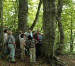
This museum faithfully reproduces the eternal history of the Sagamihara plateau and the natural appearance of the bur oak forest and spring water, and displays the specimen of animals and insects living there. The tide of life is displayed well.
This lake is an artificial lake for power generation facilities near Tsukuiko Lake, and is in the oldest stratum — 100 million years old — in Kanagawa prefecture. In this stratum, fossils of elephants and deer that came during the Ice Age, when the Eurasia Continent and the Japanese Archipelago were connected, but could not have returned when the seas rose in the interglacial period. And human historical sites also remain.
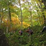
You can observe wild birds and enjoy the nature of each season on this walking path, while exploring the ancient history.
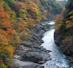
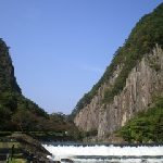
Takatsudokyo in Omamacho, is a spectacular view, and it competes with Yabakei Gorge: scenic beauty in Nakatsu Oita, named by Rai Sanyo (1781 – 1832), who was a Japanese Confucian scholar, historian and Imperialist who influenced the rise emperor-centered nationalism at the end of Tokugawa Shogunate period.
A trail of approximately 500m will be maintained from downstream of Takatsudo Bridge to upstream of Hanetaki Bridge, with a pedestrian-only walkway with 120 tiles of birds, fish, and flowers.
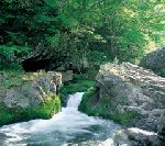
You can enjoy a fount of innocence from the mountains’ multi-layered structure, including the scenic spots of the Gorilla-rock and potholes.

The Museum speaks the seas. Tokyo Bay on the north side of Futtsu cape is a sea of tidal flats, where the river water grows lives. Uchibo, the sea between Futtsu cape and Sunosaki cape, in the west Boso Peninsula, is a warm sea where coral reefs also inhabit, under the influence of the Kuroshio, the Japan current.
The sea of Sotobo, in the east Boso Peninsula, from Sunosaki cape to Taito cape, is a place where tides move smoothly and the large seaweed Kajime, Ecklonia cava becomes the fish’s home. Kujukurihama is one of Japan’s leading sandy beaches with a sandy bottom in the sea.
Natural features surrounding the museum are also incorporated as part of the museum. A variety of outdoor events are also available.
A forest of the Kaji Hillock is located at the border between the Kanto plain and the mountains, and has a vast tea plantation. This museum introduces the natural environment and history of Iruma City, in its permanent exhibition, using a diorama that recreates the forests of the Kaji Hills. It includes the fossil footprints of the Akebono elephant (Stegodon aurorae), an ancient elephant from 2.5 – 1 million years ago that came from the Chinese continent, and was discovered on Iruma River.
This museum introduces the world’s tea scenes, the history and culture of Japanese tea, and the local Sayama tea, in the tea exhibition room. There is also a full-scale tea room of “Rikyu.” Sen no Rikyu(1522 – 1591)was the greatest tea master, and invented the wabi-sabi style of tea ceremony.
n 708, Wado, Japanese copper, was found in Kuroya Chichibu City, surrounded by the Chichibu Mountains. It was native copper, highly pure without the need for refining. It was dedicated to the Imperial Court and the era name had been changed to the Wado era (708 – 715) in the Asuka period (550 – 710) and the Nara period (710 – 794). Wado Kaiho coins were made.
Chichibu was in the center of the basin, where goods were gathered, shipped down the Arakawa River and delivered from Edo (Tokyo) to Kamakura Kanagawa and Kyoto. The town of Edo began with Chichibu.
In the Meiji period (1868 – 1912), the shipping method was switched from River to railway. But you can still experience the history of Chichibu to create Edo(Tokyo) at the Nagatoro Gorge.
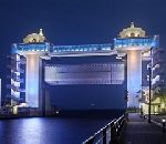
Byuo is the largest sluice gate in Japan, with a width of 40m, a height of 9.3m, and a weight of 406t. It protects 9,000 people in the hinterland of the Nubazu Port, 50ha from where a tsunami might enter the port in the east coast of Suruga Bay.
From the observation corridor, with a height of about 30m above the ground, you can see Mt. Ashitakayama, Mt. Fuji, and the Southern Alps in the north, and you can see as far as Shimizu City. You can see below the Ganyudo Coast, beyond which you can clearly see Osezaki Cape, which protrudes from Suruga Bay.
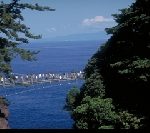
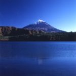
Yaizu is said to be the place where Yamatotakeru no mikoto, a legendary Japanese prince of the Yamato Dynasty, and the son of Emperor Keiko, set his enemy on fire, by their own attack, while overtaking the eastern areas, by order of the Emperor. You can see closely Mt.Fuji and the Izu Peninsula over Suruga Bay, from the Kogawa Port.
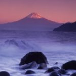
About a million years ago, the Izu Peninsula, on the Philippine Sea Plate, collided with Honshu Island, which created Suruga Bay. Eventually, Mt. Fuji was born.
Nichiren wrote ” Rissho Ankoku ron, the Treatise for Spreading Peace Throughout the Country by Establishing the True Teaching”, in 1260, when it was in the midst of natural disasters, in the Kamakura period (1185 – 1333). He presented it to Hojo Tokiyori (1227 – 1263) the 5th Shikken, the Regent of the Kamakura Shogunate, to review the national politics, and was exiled to Izu Peninsula. This coast was the place where Nichiren disembarked, which was created from Mt. Omuroyama, a volcano on the Izu Plateau.
This coast is rich in seafood and has a variety of natural modeling beauty, such as steep cliffs and the cape of flowing lava. The terraced fields of Jogasaki Flower Garden contrast with the sculptural beauty of the cape.
The view of Mt. Fuji from this coast is like a painting. The name of this place, Toi, is said to originate from the Ainu word Topi, meaning “wonderful land.” There are sites from the middle of the Jomon period (16,000 years ago – 3,000 years ago), and there is an ancient memory. On this coastal walk, you can encounter the scenery that has been beloved for over 5,000 years.
There are monuments inscribed with a poem and sculptures by the artists related to Toi, such as Wakayama Bokusui (1885 – 1928), a Japanese poet, and Shimaki Akahiko (1876 – 1926), a Japanese poet, in the pine forest of Matsubara Park. There is a history that the beautiful superb views of the sea and the sunset have been engraved in the heart of a person.
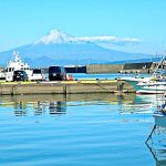
Yaizu Port on the west coast of Suruga Bay is a fishing port that represents Japan by landing tuna and bonito. Suruga Bay is curved so that the Pacific Ocean enters toward Mt. Fuji, which was created when the Izu Peninsula on the Philippine Sea Plate collided with Honshu Island, about 1 million years ago.
At this museum in the fishing port, you can enjoy learning about the deep sea of Suruga Bay with images and panels, which, at 2,500m, is the deepest sea in Japan.
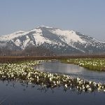
Ozegahara is the largest high attitude wetland on Honshu Island. It has created an excellent natural environment, after undergoing various changes from the volcanic activities of 5.1 million to 1.7 million years ago, and has about 900 species of Alpine plants. Ozenuma Lakeside was formed at the end of the volcanic activity, where dragonflies and butterflies stop flowers.
There is also Ozezuka tomb, with three Japanese larch, which was for Fujiwara no Tomosane, a Chunagon, a state councilor, and the retainer of Prince Mochihito (1150 – 1180), who was known as the Takakura Prince and the third prince of Emperor Go-Shirakawa (1127 – 1192). The early morning mist covering the wetland is fantastic. This place is a fount of innocence, which causes excitement.
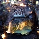
This hot spring town is located at an altitude of 1,200 m, at the foot of Mt. Kusatsu-Shiranesan, where volcanic gas met the groundwater flowing from the mountain to create the source of the hot spring.
Yubatake, a hot spring area where mineral deposits are harvested, is located in the center of this town, where a 4,000-liter hot spring springs out every minute, and the steam of the hot springs are always rising up.
There is a park around the Yubatake, where you can enjoy a walk after a bath, passing a tiled walkway, a stone fence, and the “Shiranesan bench,” which is shaped like Mt. Kusatsu-Shiranesan.
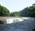
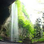
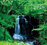
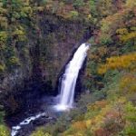
The waterfall is 7m high and 30m wide and is designated as a natural monument of Numata City. The Tonoku region used to be the fleet about 9 million years ago. The harden pyroclastic flow of a volcanic eruption was eroded by the clear stream of the Katashina River, which flows from Ozenuma Lake to the confluence of the Tone River in Numata City.
The numerous cracks in the soft rocky part appear, which look like the rocks being broken by the wind. There is a legend that the basin of the waterfall is the gate to Ryugu, a dragon palace.
This valley is about 3.5km along the Azuma River in Gunma Prefecture. You can see the beauty of the valley, such as overhanging cliffs, strangely shaped rocks, and waterfalls, after the winding path formed by the river water eroded volcanic lava, a long time ago.
With the construction of the Yanba Dam, Kawarayu Onsen, a hot spring town along the valley, sank in the dam, which had a history from the Kamakura period (1185 – 1333). And Oku-Shimako Lake appeared, which produces a mysterious color that changes many times depending on the amount of light and the time of day.

Mt. Shirane, with an altitude of about 1,200 m, has Yugama, a crater lake near the top of the mountain. It is a white rugged mountain, with almost no vegetation. The lake is 300m in diameter, with a depth of 30m. It has a white rock surface, like the face of the moon, and has Emerald green water.
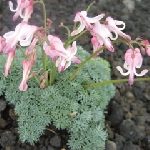
Along the promenade that circulates around the lake, Dicentra grows in colonies. It is the Queen of the Alpine plants, and has beautiful, highbrow flowers that bloom from June to July. Mysteries sympathize.
(*Entering the mountain is prohibited now, due to the volcanic activity)
Shibukawa City is surrounded by Mt. Akagisan, and Mt. Harunasan of active volcanoes, and Mt. Komochiyama and Mt. Onokoyama of dormant volcanoes. Tanashita Fudo Waterfall – Odaki Waterfall, is magnificent on the 37 − metre cliff, made by lava from Mt. Akagisan. It has the cave behind the waterfall, created by the collapse of the cliff. You can enter and look at the water fall from the back side.
You can enjoy the fount of innocence from the multi-layered mountains of the Japanese archipelago, and you can discover the value of knowing with your body, which is a different value than price.
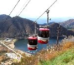
The summit of Mt. Harunafuji, with an altitude of 1,391m, can be climbed by a 2-car, fifteen seat connectable ropeway. It takes just 2 minutes and 50 seconds. Mt. Fuji can be seen from the observation deck, when it is clear.Going up the stairs from the summit station of the ropeway, is Harunafujisanjinjya Shrine.
The Harunako Lake can be seen below, where the lakeside is a paradise of flowers from spring to autumn, with azaleas, daily lily, irises, gypsy rose, gentian, and balloon-flower.
Fuji-Goko, the Five Lakes of Mt. Fuji – Motosu Lake, Saiko Lake, Kawaguchi Lake, Shojin Lake and Yamanaka Lake, are at the foot of Mt. Fuji. They were originally one lake, called Senoumi, the lake which existed at the northern foot of Mt. Fuji until the middle of the 9th century.
There was a large volcanic eruption at Mt. Fuji in 864. The lava field that was created became the origin of the Aokigahara Jukai Forest, and filled the lake of Senoumi.
The wonder is that the five lakes are filled, not with water from a flowing river, but from the underground water of Mt. Fuji. It is exactly the fresh water of this country and Wakamizu, sacred water that brings back youth.
“The Islands sunk down and floated up ” -7 million years ago, this area was connected to the Pacific Ocean via the ancient Fuji River channel, shown by the fossil of the rocky outcrop. The Jomon settlement near here, 5,000 ‒ 4,000 years ago, was connected to the Ocean through the present Fuji River, shown by the unglazed earthenware with patterns.
The fossil of the rocky outcrop, displayed beside the main gate of the museum, was excavated from the ancient Fuji River channel along the Fuji River about 7 million years ago. It indicates that whales, sharks, and sardines lived in the channel, and shellfish and sea urchins lived on the coast.
The lake side promenade of the Usui Lake is so beautiful in tender green and autumn color. It is an artificial lake with a dam at the confluence of the Nakao River and the Usui River. The Usui Pass was the bottom of the sea 12 million years ago. It is the watershed of the Tone and Shinano rivers, and was a key point connecting the Kanto region and the Shin-Etsu region (Nagano and Niigata prefectures).
In the early times, the bridge was constructed of bricks with short spans and stone columns on the Usuitoge Pass, referring to the modern German mountain railway. You can meet the heritage bridge of wisdom and ingenuity on the promenade.
This park is an experience-oriented theme park, where you can experience driving electric locomotives and ride on trolleys, using the discontinued line between Yokokawa and Karuizawa on the Shin-Etsu Main Line. The history of the Usui Pass is conveyed with the exhibition and the opening of trains to the public.
The Usui Pass was at the bottom of the sea 12 million years ago. It rose due to crustal movements, and steep cliffs were formed due to river erosion. It became the gorge with a steep slope.
Crossing the Usui Pass on the Tosan-do Road, an ancient division of the country and the main road running through it, situated along the central mountains of northern Honshu, Tohoku region, was a symbol of entering the Eastern Provinces, since ancient times.
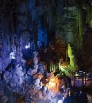
Abukuma Cave, which rose up from the sea over 80 million years ago, is located at the foot of the Abukuma Highlands, which runs north to south on the east side of Fukushima Prefecture. Inside the cave, with a total length of about 600m, stalactites that dramatically hang from the ceiling and stalagmites that accumulate from under the floor are constantly changing. They are the beauty that groundwater creates, which is a masterpiece. Memories of the ancient seabed remain here. You should watch “Tsuki no Sekai, -the Moon World,” which features a light control system for stage productions.
Hakkoda Mountains has a balance between the northern half of Tashirotai Wet Land, which was depressed due to volcanic eruption, and the southern half of Mt. Hakkoda-Odake, which is elevated.
From June, the Hakkoda Wetland in the southern foot of Mt. Tamoyachidake has flowers of rhododendron japonicus, eriophorum vaginatum, Japanese azalea, Poona japonica, and cranberry. In summer, flowers of nikokisuge: broad dwarf day lily, unicom root and narthecium asiaticum make the wetland a golden sea.
Goshoko Lake is an artificial lake dammed by the Shizukuishi River that flows through the Kitakamigawa River. Several recreational facilities, including Shiogamori Mizubeenchi Lakeside Park and the Goshoohashi Sports Ground, can be found around the lake.
The Oiriono Botanical Garden of Wetlands in this lake park has the blossom of skunk cabbages in the beginning of April, rabbit-ear iris from late May to early June.Fireflies can be seen in the middle and the end of July. Red and white water lilies bloom in the two ponds in the end of July.
Rikuchu Kaigan National Park runs along the coastline from northern Iwate Prefecture to northern Miyagi Prefecture. Kitayamazaki is a natural scenic spot, with a precipitous cliff, located at the north of the park. Nasu Volcanic Zone has been active for 26 million years and has risen from the sea, parallel to the Japan Trench.
Kitayamazaki is the middle of the plateau, extending from Kurosaki in the north to Bentenzaki in the south. The sculptural beauty of nature, with a height of 50 to 200 m, can be seen from the sea, along with the Black-tailed seagulls. Its beauty is overwhelming.
Asamushi Onsen is a tourist destination with many leisure activities, including sea bathing, skiing, and aquariums. Munakata Shiko (1903 – 1975) was a woodblock print artist from Aomori Prefecture, and a world-class master of the 20th century art. His work is a brilliant life force emerged.
He created works that express a willingness of the strong order and harmony with traditional Japanese style and designs. Munakata loved the nature and hot springs of Aomori prefecture, where he was born and grew up.
The Kuji clan in Nanbu moved to Ajigasawa Town in the Muromachi Period (1366 – 1573), and established Tsugaru Domain. Ajigasawa Town Aomori Prefecture, is located at the base of the Tsugaru Peninsula, which prospered as the port of the Tsugaru Domain. The Shirakami Forest had been carefully protected as a preserved forest in order to secure water for rice fields during the days of the domain administration.
The beech forest that preserves the water of grace is located in the Kuromori district, 20 km north of the Shirakami Mountains, which is a World Heritage Site. There is rich grace from the natural broadleaf forest. (*Operation is suspended now, due to the appearance of bears)

Hakkoda Mountain is a general term for volcanic groups that rise to the south side of Aomori city. Mt. Hakkoda-Odake, with an altitude of 1,584m and Mt. Tamoyachidake are lined up at the same height. Hakkoda Mountains have a balance between the northern half of Tashirotai Wet Land, which was depressed due to the volcanic eruption, and the southern half of Mt. Hakkoda-Odake, which is elevated.
You can enjoy watching Alpine plants on the nature trail, which takes less than 1 hour in summer, and the best view of rime in Japan, in the winter, is on this ropeway, which takes 10 minutes to reach the summit.
This park is located at Obara, Shiroishi City along the Shiroishi river, which flows as a water source to the southeast, from the Zao Mountain Range. A natural monument, Zaimokuiwa, a rock wall was formed 12 to 23 million years ago, which looks like a huge tree standing vertically. Zaimokuiwa was damaged as much as Shiroishijo Castle due to the East Japan Great Earthquake in 2011, and a part of the rock surface collapsed. Koinobori, carp-shaped streamer, a traditional event to pray for boys to grow up healthy and strong by raising the streamers all over Japan, was sent to support the reconstruction efforts after the great earthquake, and 800 Koinobori are fluttering well in the Shiroishi river, in May. The mind of Oshu (Northern Honshu, the region encompassing Mutsu and Dewa province), which has a high crystal purity, made by an overlapping natural appearance, was revived.
During the Nara period (710 – 794), Ishikawa Town, in Iwaki province was the gateway to Mutsu Province, the northeast region of Honshu Island. It is where Minamoto no Arimitsu (1037 – 1086), a military commander in the Minamoto clan, and the 2nd head of the Ishikawa clan, moved to, from Settsu Province Osaka, developed and ruled. Ishikawa Town is said to be the birthplace of Izumi Shikibu (Born 876) a Japanese female poet and a femme fatale with numerous lovers. Kowashimizu, spring water, still springs out, which is said to be used for Shibiku’s first bath as a baby.
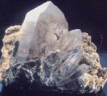
This area had been one of the three major mineral producing areas in Japan, since ancient times. The largest and most beautiful crystals in Japan have been collected, and more than 150 species have been discovered. Those are introduced at this museum.
Mt. Iwaki, a double volcano with an altitude of 1,625 m, is also called “Tsugaru Fuji” because it looks like Mt. Fuji. It has a conical shape that looks like it has sprung up in the Tsugaru Plain, and its ridge line is beautiful.
There are many hot springs at the foot of the mountain, and Iwakiyamajinjya Shrine is at the south foot of the mountain, and Takaterujinjya Shrine is to the east. Mt. Iwaki has been worshiped as a holy mountain.
On August 1 of the lunar calendar, the Mountain pilgrimage festival called “Oyama-Sankei” is held. The pilgrims climb to the rear shrine at the summit and pray for Gokokuhojyo, a bumper crop, the safety of the family, and they worship the rising sun.
The Oirase River is the only river in Towada Lake that has a large amount of water. The Choshi Otaki Water Fall resembled the spout of Tokuri, a bottle of sake and a large waterfall. Therefore, fish could not go over the fall. The Towada Lake used to have no fish. Kujo Takeko (1887 – 1928), a Japanese Waka poet and humanitarian, saw the mysterious jade-colored flow and made the poem: “Amarinimo Shinka toshite Ningeno Ayamachite irishi Sakai katoomofu – It’s too quiet to let me feel to come to the border in the wrong way”.
The museum also displays the ecosystem of plants and animals related to the Towada Lake and the Oirase Mountain Stream.
Bense Wetland is a valuable, coastal, 23ha Wet land of low attitude at the southern limit. It takes about 15 minutes by car from Kamegaoka, Kizukuri Tsugaru City, where Google-eyed clay figurines from the final Jomon period, 3,000 – 2,000 years ago, were excavated. The wetland is colored yellow in the beginning of June, by the colony of Nikokisuge, a Broad dwarf day lily, and purple in the end of June, by in colony of Iris ensata.
It is very rare that the group of hygrophyte exist near the coast, and it is limited to the wetlands of this area on Honshu Island and the area in northeastern Hokkaido Island.
The folk performing art, “Onikenbai – Devil’s Sword Dance”, which has been transmitted to the secret hot spring, Geto Onsen, has a 1,300 year history. This performance, with a demon mask and a vigorous dance, is the sword dance for Amida Buddha (the principal image of Buddha in Pure Land). The name of the hot spring is derived from Guto, in the Ainu language, which means the place of the cliff.
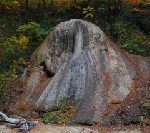
The natural monument, Sekaika, Precipitates of calcium carbonate that can be found at hot springs and other springs, is Japan’s largest fountain dome, with a height of 17m above the river and a width of 25m at the bottom. It is made from the same process as the limestone cave and is also called “Tenguiwa – large long-nosed goblin shaped rock”.
Naruko Gorge is located in Osaki City, Miyagi Prefecture near the prefectural border with Yamagata. It is a natural sculpture created by the Oyagawa River that connects to the Eaigawa River. It represents the elegance of poetic unconventionality, which had been pursued by Matsuo Basho (1644 – 1694), the most famous poet of the Edo period. There are winding mountain streams harmonizing with steep cliffs and random rocks.
Katanuma Lake is a crater lake in the Naruko Volcanic Group, which was dammed by lava flow. It appears a deep mystery on the surface of the emerald green.
The forest around this center has been known as a paradise for wild birds for a long time, and Kotori House collects the natural environment and the four seasons of Miyagi Prefecture, mainly on the Zao Mountain Range. This center explains the mechanism of nature, the nature of the Zao Mountain Range and the ecology of wild birds in Miyagi Prefecture, using models and taxidermy. The Center hosts public events including Wild bird care and nature observation events.
You can experience the elegance of poetic unconventionality that was pursued by Saigyo (1118 – 1190), a Japanese poet who worked as a guard to retired Emperor Toba (1103 – 1156), Sen no Rikyu(1522 – 1591), the greatest tea master, and the tea master to the military dictators of Japan, Oda Nobunaga and Toyotomi Hideyoshi, who invented the wabi-sabi style of tea ceremony, and Matsuo Basho (1644 – 1694), the most famous poet of the Edo period.

The Ramsar Convention registers wetlands that are internationally important as habitats for waterfowl. Hotokenuma is a Wet land of low attitude registered under the Ramsar Convention, which was originally a reclaimed land. It faces Ogawarako Lake, with a depth of 2m from the shore to 200m, where the reed bed spreads. The reed bed is divided into the zone of low and moderate height in the north and high in the south.
Japanese marsh warblers, the symbol of Hotokenuma Wetland, can be seen around the Sankaku Pond in the section of the North Entrance and Sanbonmatsu – three pine trees, in the section of the northwest.
This natural park consists of the Hiraniwakogen Highlands and the Kujikeiryu, mountain stream. The Kujigawa Gorge collects water from the Kitakami Mountains and it pours it into the Pacific Ocean. It is a popular spot for mountain stream fishing in the summer. Kagamiiwa is a limestone wall was named “rock mirror,” because the wall reflects in the mountain stream.
The famous water, Furosen, spring water, is beside Kagamiiwa, which is selected as one of the 23 best waters in Iwate Prefecture. It is fresh water of Japan, which is Wakamizu, sacred water that brings back youth. The Kitakami Mountains spring out the water, which is presumed to have been raised in the Cretaceous period (145 million – 66 million years ago) by the collision of the Northern Mountains and the Southern tectonic zone in the Southern Ocean, which came up to the north.
This mountain is famous as “Flowers Mountain”. Hayachineusuyukiso is a species of plant that is related to, and resembles, Edelweiss. There are also several endemic species, such as Nanbunotoranoo, a species of common bistort, and about 200 alpine plant species are in full bloom in the rocky ridge above the forest line, 1,300m above sea level.
It is the oldest Mesozoic Era area in Japan and is a relict mountain that survived erosion during the Ice Age. It is the highest mountain in the Kitakami Mountains, and the view is exceptional.
Large Keyaki, Japanese zelkova, which are 300 year old trees with diameters of more than 2 m, grow in clusters on this promenade, along the Gobyakugawa River flowing into Koriyama City. Each Keyaki has a complex appearance, of which the sculptural beauty is overwhelming. The 400m of the promenade, with its well-balanced natural environment, is well maintained.
The name of the Gobyakugawa River means the 500th river. It is said that Hagi Hime, who was a princess in the Northern and Southern Courts (1336 – 1392), became sick, and travelled to the 500th river in the north of Kyoto, following the oracle in her dream, and recovered.
Hachimantai belongs to the northern part of the Ou Mountains and spreads evenly in Iwate and Akita prefectures. The Nasu Volcanic Zone has been active for 26 million years. It is a trace of a volcano that rises from the sea in parallel with the Japan Trench and has a gentle slope. There are Maries’ fir virgin forest, like those at Mt. Gentamori and Alpine plants.
There are also many large and small swamps, including Hachiman-numa. There are plenty of guides to accompany you on a nature walk, and you can enjoy the highland stroll.
Oyu Onsen, a hot spring is located 25km south of the Towadako Lake, a mysteriously quiet lake that stretches over Aomori and Akita prefectures. The lake has a maximum depth of 334m and is a deep blue lake. Scenic spots of waterfalls continue along the Oyugawa River, which is rich in water. Nishikimi Water Fall sprays like a fog on the rock surface of the plate-shaped and the regular alternating layers of Columnar Joint. Choshinotake Water Fall sometimes falls like breaking a precipice and sometimes falls quietly, and scenic spots of waterfalls continue,,,.
It is the universal beauty of Japan which dynamically and constantly changes shape.
Takamura Chieko (1886 – 1938), was a Japanese artist of painting and colorful cut paper. She was the wife of Takamura Kotaro (1883 – 1956) a Japanese poet and sculptor. Kotaro wrote “Chiekosho” – Chieko’s Sky, a book of poems by Kotaro. The true sky of Chieko that was described in Kotaro’s “Chieko-sho” is the view of Mt. Adatarayama, seen from the Chiekonomori Park.
This mountain belongs to the Nasu Volcanic Zone in Bandai Asahi National Park. It is also called ” Mt. Nyutosan” with an altitude of about 1,700m. It is one of the 100 most famous mountains in Japan. There are many Alpine plants, as such the natural monument, rhododendron (a rosebay), which blooms in the early summer. The beautiful mountain stream makes mountain climbers very happy.
“Seasonal Events in Akita” was painted by Fujita Tsuguharu (1886 – 1968), a Japanese-French painter. It is 3.65m high by 20.50m wide and depicts a festival and life in Akita in 1937.
This museum exhibits other works of Fujita, which are the collection of Hirano Masakichi (1895-1989), a wealthy person from Akita Prefecture.
It aims to foster a culture that coexists with the town, people, and culture of Akita, where the citizens of the prefecture can enjoy and create art. In addition, you can fully enjoy the beautiful scenery of Senshuu Park in the site of Kubotajo Castle, through the water garden at the lounge.

Mt. Yakeishidake, with an altitude of 1,548m, spans both Iwate and Akita prefectures. It is covered with the beech virgin forest and is rich in Alpine plants. The mountain trail sometimes becomes like a river with snowmelt water. With abundant water, there are many wetlands, ponds and swamps on the mid slope, creating a magnificent flower garden. Alpine plants bloom near the summit, from where the Japanese Alps can be seen. Even at an altitude of 1,000m, the low latitude of the Tohoku region creates a reservoir of flowers.
The Province border in Ritsuryo system, a system of centralized government based Ritsu, a criminal code and Ryo, an administrative code, was drawn along the watershed, in the Nara period (710 – 794). The central watershed that divides the flow into the Sea of Japan and the Pacific Ocean runs through the Zao Mountain Range.
In that range are Fudotaki Falls, Sankainotaki Falls, and Jizotaki Falls in the Sumikawa River. From the Takimidai on the Zao Echo Line, you can see the Fudotaki Falls, which is listed in the Top hundred Water Falls, and Sankainotaki Falls. Fudotaki Falls, which is 53.5m in height and 16m in width, is a Great Falls of Japan. It is also a flow that divides the ancient Province.
Mt. Akita-Komagatake is an active volcano with an altitude of 1,637m, which straddles Semboku City Akita and Shizukuishi Town Iwate. From the summit, you can see magnificent mountain ranges, such as Mt. Chokaizan and Mt. Iwate, and the Tazawako Lake, which shines in the azure. It is also best known for its flowers and Alpine plants, among the many Komagatake mountains in Japan.
Around July, the pretty and highbrow Dicentra blooms, which is the Queen of the Alpine plants. In the summer, avens blooms which grows in colonies on the top of the meadow and rock ridge.
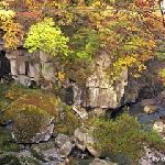
The Natori River flows from Sendai City to the Pacific Ocean. It flows eastward from Mt. Kamurotake of the Ou Mountains, with an altitude of 1,356m. Rairaikyo Gorge is located near Yumoto in Akiu Onsen, a hot spring, where the flow of the Natori River is very narrow. The Gorge has strangely shaped rocks, which was created by the river eroding the Akiu stone, tuff.
There is Akiuotaki Waterfall at the upper reach, which is Three Outstanding Water Falls next to Nachi Waterfall, and Kegon Waterfall and is, 55m high and 6m wide. You can see the power of nature in the Natori River basin.
The mysteriously beautiful Hibara Lake was formed by the eruption of Mt. Kobandai in 1888, and has Hibarajuku, post town at the bottom of the lake, which was on Yonezawa Kaido Road connecting Yonezawa and Aizue. The Torii, a gateway at the entrance to the shrine in the post town, appears on the surface of the lake. Urabandai’s volcanic activity began about 900,000 years ago. A record of the volcanic activity remains in the 1000 years – in 806, and in 1888. This visitor center guides you to the fount of innocence to encounter living with nature.
Jododaira Plateau, at an altitude of 1,600m, is about an hour from Fukushima city. It is covered with the virgin forest of coniferous trees and cute Alpine plants. You can also see Mt. Azumakofuji, Goshikinuma Ponds, and Zao Mountain Range from Mt. Issaikyoyama on the Jododaira Plateau.
The wetland on the Plateau has been affected by repeated volcanic activities, and various types of plant colonies have developed. This Visiter Center guides you to the richness of the wetland, as a fount of innocence.

The name of Sapporo City comes from “Sapporo Betsu”, which means the big dry river in Ainu language. The flow of the Toyohiragawa River, flows through the Ishikarigawa River into the Sea of Japan, which faces the mother, Eurasia Continent from a distance. The Hoheikyo Dam supplies water to Sapporo City, via the Hoheikyo Gorge, which used to be called “the precipice of God” by Ainu people.
The magnificence of the lake and greenery makes it one of the most scenic spots in Sapporo City. It has a universal scenic beauty that transcends the state.
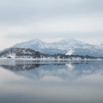
This lake is the crater lake of the Kuttara Volcano in the eastern part of Noboribetsu Onsen, hot spring, with an 8km circumference and 147m water depth. It is a mysterious lake, inhabited by Ezo salamanders, not appeared normally. There are no rivers that feed into nor out of the lake and it boasts one of the most transparent waters in Japan.
This lake is surrounded by various plants and virgin forest, where you can experience the mystery of the scenery that has existed since ancient times. It is also fun to see 20m down into the lake. It is a source of innocence!
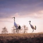
Kushiro Shitugen is Japan’s largest wetland where the Kushiro River flows through eastern Hokkaido and into the Pacific Ocean. The plain area preserves a primitive natural environment. The large natural horizontal landscape is unique in Japan. It is also a valuable habitat for many natural animals and plants, including the special natural monument, the Tancho, a Red crested Crane.
It became the first Ramsar Convention wetland in Japan in 1980, and has been designated as a national park. The Tancho population in Kushiro Shitsugen was reduced by hunting and environmental changes. At one time, it was thought to be extinct, but after various protective activities the population was restored.
Now, you can see them here and in eastern Hokkaido. Wetlands are not only transit points and breeding areas for migratory birds, but they also retain water to mitigate river flow and regional weather fluctuations, purify water quality, and maintain biodiversity.
It has a Good Value that cannot be solely economic value.