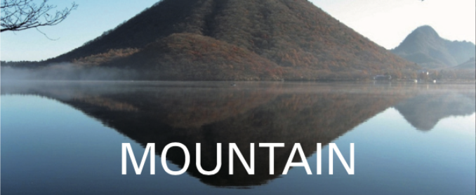


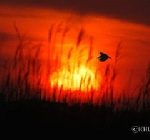
Ozegahara is the largest high attitude wetland on Honshu Island. It has created an excellent natural environment, after undergoing various changes from the volcanic activities of 5.1 million to 1.7 million years ago, and has about 900 species of Alpine plants. Ozenuma Lakeside was formed at the end of the volcanic activity, where dragonflies and butterflies stop flowers.
There is also Ozezuka tomb, with three Japanese larch, which was for Fujiwara no Tomosane, a Chunagon, a state councilor, and the retainer of Prince Mochihito (1150 – 1180), who was known as the Takakura Prince and the third prince of Emperor Go-Shirakawa (1127 – 1192). The early morning mist covering the wetland is fantastic. This place is a fount of innocence, which causes excitement.
Hakkoda Mountains has a balance between the northern half of Tashirotai Wet Land, which was depressed due to volcanic eruption, and the southern half of Mt. Hakkoda-Odake, which is elevated.
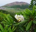
From June, the Hakkoda Wetland in the southern foot of Mt. Tamoyachidake has flowers of rhododendron japonicus, eriophorum vaginatum, Japanese azalea, Poona japonica, and cranberry. In summer, flowers of nikokisuge: broad dwarf day lily, unicom root and narthecium asiaticum make the wetland a golden sea.

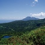
Hakkoda Mountain is a general term for volcanic groups that rise to the south side of Aomori city. Mt. Hakkoda-Odake, with an altitude of 1,584m and Mt. Tamoyachidake are lined up at the same height. Hakkoda Mountains have a balance between the northern half of Tashirotai Wet Land, which was depressed due to the volcanic eruption, and the southern half of Mt. Hakkoda-Odake, which is elevated.
You can enjoy watching Alpine plants on the nature trail, which takes less than 1 hour in summer, and the best view of rime in Japan, in the winter, is on this ropeway, which takes 10 minutes to reach the summit.
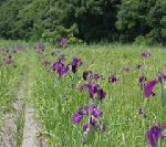
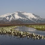
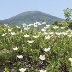
Bense Wetland is a valuable, coastal, 23ha Wet land of low attitude at the southern limit. It takes about 15 minutes by car from Kamegaoka, Kizukuri Tsugaru City, where Google-eyed clay figurines from the final Jomon period, 3,000 – 2,000 years ago, were excavated. The wetland is colored yellow in the beginning of June, by the colony of Nikokisuge, a Broad dwarf day lily, and purple in the end of June, by in colony of Iris ensata.
It is very rare that the group of hygrophyte exist near the coast, and it is limited to the wetlands of this area on Honshu Island and the area in northeastern Hokkaido Island.
The Ramsar Convention registers wetlands that are internationally important as habitats for waterfowl. Hotokenuma is a Wet land of low attitude registered under the Ramsar Convention, which was originally a reclaimed land. It faces Ogawarako Lake, with a depth of 2m from the shore to 200m, where the reed bed spreads. The reed bed is divided into the zone of low and moderate height in the north and high in the south.
Japanese marsh warblers, the symbol of Hotokenuma Wetland, can be seen around the Sankaku Pond in the section of the North Entrance and Sanbonmatsu – three pine trees, in the section of the northwest.
Hachimantai belongs to the northern part of the Ou Mountains and spreads evenly in Iwate and Akita prefectures. The Nasu Volcanic Zone has been active for 26 million years. It is a trace of a volcano that rises from the sea in parallel with the Japan Trench and has a gentle slope. There are Maries’ fir virgin forest, like those at Mt. Gentamori and Alpine plants.
There are also many large and small swamps, including Hachiman-numa. There are plenty of guides to accompany you on a nature walk, and you can enjoy the highland stroll.
“Seasonal Events in Akita” was painted by Fujita Tsuguharu (1886 – 1968), a Japanese-French painter. It is 3.65m high by 20.50m wide and depicts a festival and life in Akita in 1937.
This museum exhibits other works of Fujita, which are the collection of Hirano Masakichi (1895-1989), a wealthy person from Akita Prefecture.
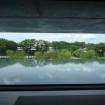
It aims to foster a culture that coexists with the town, people, and culture of Akita, where the citizens of the prefecture can enjoy and create art. In addition, you can fully enjoy the beautiful scenery of Senshuu Park in the site of Kubotajo Castle, through the water garden at the lounge.

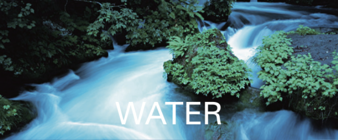
Mt. Yakeishidake, with an altitude of 1,548m, spans both Iwate and Akita prefectures. It is covered with the beech virgin forest and is rich in Alpine plants. The mountain trail sometimes becomes like a river with snowmelt water. With abundant water, there are many wetlands, ponds and swamps on the mid slope, creating a magnificent flower garden. Alpine plants bloom near the summit, from where the Japanese Alps can be seen. Even at an altitude of 1,000m, the low latitude of the Tohoku region creates a reservoir of flowers.
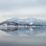
Mt. Akita-Komagatake is an active volcano with an altitude of 1,637m, which straddles Semboku City Akita and Shizukuishi Town Iwate. From the summit, you can see magnificent mountain ranges, such as Mt. Chokaizan and Mt. Iwate, and the Tazawako Lake, which shines in the azure. It is also best known for its flowers and Alpine plants, among the many Komagatake mountains in Japan.
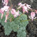
Around July, the pretty and highbrow Dicentra blooms, which is the Queen of the Alpine plants. In the summer, avens blooms which grows in colonies on the top of the meadow and rock ridge.
The mysteriously beautiful Hibara Lake was formed by the eruption of Mt. Kobandai in 1888, and has Hibarajuku, post town at the bottom of the lake, which was on Yonezawa Kaido Road connecting Yonezawa and Aizue. The Torii, a gateway at the entrance to the shrine in the post town, appears on the surface of the lake. Urabandai’s volcanic activity began about 900,000 years ago. A record of the volcanic activity remains in the 1000 years – in 806, and in 1888. This visitor center guides you to the fount of innocence to encounter living with nature.
Jododaira Plateau, at an altitude of 1,600m, is about an hour from Fukushima city. It is covered with the virgin forest of coniferous trees and cute Alpine plants. You can also see Mt. Azumakofuji, Goshikinuma Ponds, and Zao Mountain Range from Mt. Issaikyoyama on the Jododaira Plateau.
The wetland on the Plateau has been affected by repeated volcanic activities, and various types of plant colonies have developed. This Visiter Center guides you to the richness of the wetland, as a fount of innocence.
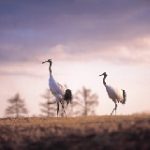
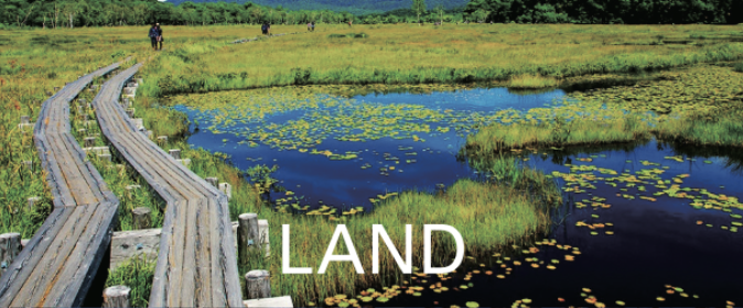
Kushiro Shitugen is Japan’s largest wetland where the Kushiro River flows through eastern Hokkaido and into the Pacific Ocean. The plain area preserves a primitive natural environment. The large natural horizontal landscape is unique in Japan. It is also a valuable habitat for many natural animals and plants, including the special natural monument, the Tancho, a Red crested Crane.
It became the first Ramsar Convention wetland in Japan in 1980, and has been designated as a national park. The Tancho population in Kushiro Shitsugen was reduced by hunting and environmental changes. At one time, it was thought to be extinct, but after various protective activities the population was restored.
Now, you can see them here and in eastern Hokkaido. Wetlands are not only transit points and breeding areas for migratory birds, but they also retain water to mitigate river flow and regional weather fluctuations, purify water quality, and maintain biodiversity.
It has a Good Value that cannot be solely economic value.