
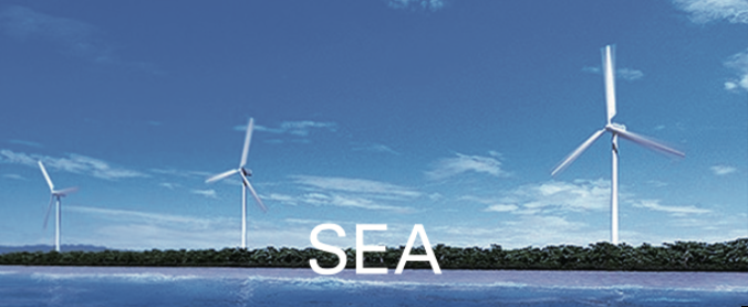
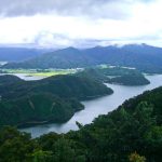
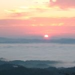
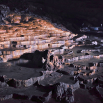
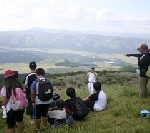
A special scenic spot Amanohashidate, is a miracle of natural modeling that exists like a white bridge flying to heaven. At the slightest twilight of the evening, the “the railway crossing the sea” appears when the sun illuminates the pine forest from the side. Originally, it was a bridge to heaven.
The bridge connected to heaven hanged over Hioki Miyazu City, and the gods came down. Then, many people in the land tried to cross toward the heaven, and it collapsed. It has been said that the wreckage of the bridge became Amanohashidate.
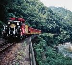
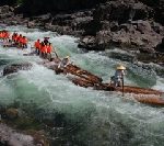
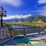
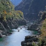
Tamba Province had supported the Heiankyo Capital of Kyoto by sending products such as wood, firewood and charcoal. The wood was delivered by rafts down the Hozu River. Suminokura Ryoi (1554 – 1614), a wealthy merchant and shipper of overseas trade, took care of the development of Hozukyo Gorge, in the Keicho era (1596 – 1615) of the Edo period.
Althoough Ryoi developed the Fuji River in Yamanashi and the Tenryu River in Nagano, it was extremely difficult for him to develop the Gorge, which had the mythology of Okunushi no Mikoto, the deity of magic and medicine, and the original the ruler of Izumo Province, Shimane, who was enshrined at Izumo Grand Shrine.
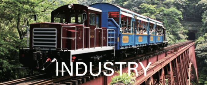
A railway was laid in 1899 in the difficult Gorge, and the trolley replaced the Takasebune, flatboat of Ryoi. It was a symbol that the days had changed from the early modern times to the modern times.
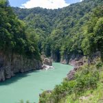
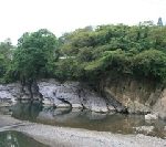
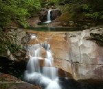
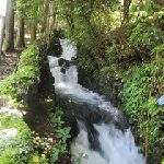
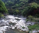
This gorge is located in the upper reaches of the Aizu River, which flows through the center of Tanabe City. There are countless numbers of strangely shaped rocks of all sizes. Above the Fudo Water Fall, Magai Sanson Dai Sekibutsu, the stone-cliff sculpture of the Three Great Buddhas images are engraved in a single rock, which was based on an original painting by Domoto Insho (1891 – 1975), a Japanese painter. The special harmony with the landscape is spectacular.
Through the harmony, you can experience the intersection of the causality of inevitability and the contact of by-chance, mentioned by Minakata Kumagusu (1867 – 1941), a Japanese author, biologist, naturalist and ethnologist. Kumagusu guided that you could know many of the natural principles at once, at this intersection.
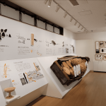
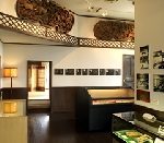
The museum’s possessions trace the genealogy of modern Japanese painting. It’s possessions also trace painters of the literary school in the early modern times in Japan. These came from the cultural salon of Ikeno Taiga (1723 – 1776), a Japanese painter and calligrapher, Yosa Buson (1716 – 1784), a Japanese poet and painter of the literary school, and beginning with Gion Nankai (1676 – 1751), a Japanese Confucianist, author and painter of the literary school.
These works have a common approach – they let the mind stroll with the mechanism of nature and beauty, with the knowledge from abroad and from overseas. The journey through the beauty at this museum is another Pilgrimage to the three main Kumano shrines.
The Kitayamagawa River flows to Kumano-nada Sea from Mt. Odaigahara, which is one of the world’s rainiest areas. Dorokyo Gorge extends for about 31km. It’s beauty had been created from erosion. You can enjoy the magnificent scale of natural sculptural beauty by driving to the place, Doryokyo Meguri no Sato Kumanogawa Shiko, which has been revived with many restaurants and souvenir shops.
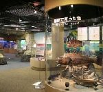
This museum introduces the geography and history of Iso Hikamicho, which has a central watershed on Honshu Island. The flow of water divides the Seto Inland Sea and the Sea of Japan at Iso Hikamicho, which is the lowest point in Japan, at an altitude of 100m.
This museum exhibits a model of the topography of the watershed and a full-scale model of Takasebune, a flatboat, that conveys the history of the Kakogawa River boat transportation. This museum introduces the fem (pteridophyte) of a southern species that lived north of the border and Minamitoyomi, pungitius kaibarae, the extinct north-stream fish that appeared south of the border.
The Kitayamagawa River flows to Kumano-nada Sea from Mt. Odaigahara, which is one of the world’s most rainy areas, to Kumano Sea. The beauty of the 31km long Gorge was created by repeated erosion.
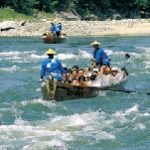
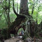
In Kitayama village, the wood cut went down the Kitayamagawa River, by rafts, to Shingu City since ancient times. The rafting was reproduced in 1979, for sightseeing. It used to ship wood to the mouth of the river.
It is the only river rafting in Japan, where you can experience the causality of inevitability and the contact of by-chance.
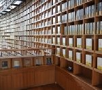
Shortly after Shiba Ryotaro (1923 – 1996) died, this museum opened (November 2001) in the author’s memory. It consists of Shiba’s house and a building designed by Ando Tadao (1941 – ), a Japanese architect from the adjacent land. You can see Shiba’s study room from the small path through the window, in the garden of a thicket, which changes from season to season. This is the memorial hall of “try to feel” and “try to think” with the large three-storied open shelves, with a height of 11 meters, that holds about 20,000 books.
– Shiba said that the prototype of Japan has been as clear and plain as spring mineral water since ancient times.
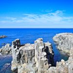
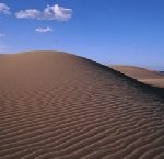
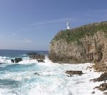
This park spans approximately 75km from the Amino Coast of Tango Peninsula to the Tottori sand dunes. It consists of sea-cliff terrain, cave entrances, beach terrain, and the Kyotango Kumihama Coast. Both are the oldest stratum in the Japanese archipelago, and are from rocks raised above the seabed, containing a large amount of iron.
Hasakariiwa Rock at the Takeno Coast was sandwiched between the rocks on the side walls as the ceiling rock tried to fall into the sea. The dunes represent the time of migration and this rock represents the time of immobility.
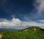
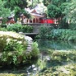
This refreshing garden is located at the top of Mt. Maya, which was named by Kobo Daishi Kukai (774 – 835), the founder of the Shingon sect, for the enshrined statue of Queen Maya, the Mother of Buddha, at this mountain. This mountain was also named Hashumine, the ridge that overlooks 8 provinces, where Shugendo, Japanese mountain ascetic practices have taken place, since ancient times.
The historic site of the ascetic practices remains in the garden, too. Nunobiki no Taki originated from this garden. It was praised as a famous mineral water by the ocean-going ship of a port of call to Kobe, after opening the port.
This observation garden combines the diversity of nature with the historical and cultural heritage.
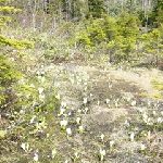
This park helps you feel and think about water. The backbone range runs through the Japanese archipelago and rain branches into the Seto Inland Sea in the south and the Sea of Japan in the north at the central watershed. This park is at the foot of Mt. Kiyomizuyama, with an attitude of about 100m at Hikamicho Tanba City, which is the lowest, easternmost point of the central watershed of Honshu Island.
The climate, flora and fauna change beyond the watershed border, but those distinctions are vague at the border. There are colonies of dogtooth violet in a cold district. There are realities of nature that exceed the common sense of science.
The area of approximately 110 km east to west of Kyoga Cape, Kyoto Prefecture, and the Hakuto Coast in Tottori prefecture, has a variety of coastal landforms such as Rias coasts and sand dunes, created with igneous rocks and stratum. Sea level changes and crustal movements contributed to the formation of the Sea of Japan, 25 million years ago.
The center exhibits a model explaining the stratum on the Sanin Kaigan, coast, and Geoheritage – basalt, andesite, and tuff of geo-site in the area. The center also supports learning of geo-site.
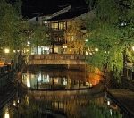
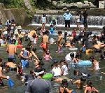
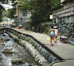
Kinosaki Onsen is in the famous hot spring area in Hyogo prefecture, which opened 1,300 years ago. The scene of the Line of Willows and the Otanigawa River with the arched bridge is typical scenery of the Onsen, where Shiga Naoya (1883 – 1971), a Japanese novelist, also liked the quiet atmosphere. There are 7 open air baths scattered in the hot spring town, and you can enjoy different hot spring baths.
– “A Dark Night’s Passing” is the novel by Shiga Naoya, which has the scene of Kinosaki Onsen. Even when you’re sailing on a dark night, you can reach the land of dawn by touching the richness of nature.
The flow continues from the huge sea of 10,000 years ago, Kinusaki no Umi fleet. – The Otanigawa River used to be Kinusaki no Umi fleet.
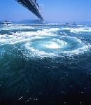
Tosa Diary, was a poetic diary by Ki no Tsurayuki (872? – 945) in the 10th century, who was a Japanese author, poet and courtier of the Heian period. Naruto Strait, Awaji Hyogo was the place where Tsurayuki prayed to the gods and Buddhas with anxiety on the trip from Tosa Province Kochi back to Kyoto, the capital, while reliving the memories of his daughter, who was lost in Tosa Province.
The whirlpools that appear on the shallow coast of Naruto Strait is the same as those thousands of years ago when the Tosa Diary was written. The whirlpools are created with the reunification of the tide to go straight from the Pacific Ocean and the tide that bypasses Awaji Island. That phenomenon overlaps Izanagi, the male deity who fathered Japan and Izanami, the female deity who mothered Japan, in the mythology of Kuni-umi (the birth of the land of Japan) and Kami-umi (the birth of the God of Japan).
They say the whirlpools are Izanagi and Izanami going round and round. Ama no Mihashira, the heavenly pillar on Onokoro Island, was built by Izanagi and Izanami to give birth to the Islands and Gods.
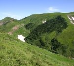
The area near the top of Mt. Makihatayama is covered with abundant Alpine plants and virgin forest. There is a mountain trail in Niigata Prefecture, whose elevation rises 1,500m.
There is a famous waterfall, such as Fukiage no Taki, Fukiage Water Fall, where water blows up into the sky, Aigame no Taki, Aigame Water Fall where pure blue water flows down, and Waremekisawa Swamp, with its strangely shaped rocks. Rhododendron (a rosebay), Nikokisuge, Broad dwarf day lily, and Primula cuneifolia bloom there in the spring.
You can also enjoy the snowy gorge walks in summer.
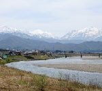
The framework of Omachi City was built by the Nishina clan, which had reigned from the Heian period (794 – 1185) to the Muromachi Period (1366 – 1573). Mt. Kashima Yarigatake can be seen from the city, which consists of the South and North peaks and is the leading mountain of the Ushiro-Tateyama Mountain Range in the Northern Alps.
The Kurosawakogen Highland, with an altitude of 1,130m, is spread with wetlands and grasslands, and is surrounded by flowers each season.
There are Three Lakes of Nishina – Kizakiko Lake, Nakatsuna Lake, and Aokiko Lake, to the east of the Kurosawakogen. They are the only natural lakes at the foot of the mountains in the Northern Alps. Walking with the scenery of the lake and the mountain, makes you feel at ease.
This coast has a beautiful contrast among the clear blue Sea of Japan, the sandy beach and the green of pine trees. The contrast began in 1620, in the beginning of the Edo period (1603 – 1868), when the lord of Murakami tried to protect the land from the sand and sea breeze. He built a fence to protect the mansion and fields and planted red pine trees to protect the residences and the fields. The trees have been protected for 400 years by a logging prohibition order.
The sunset seen from the coast of “100 famous Beautiful Sunsets in Japan” is exceptional. Slabs engraved with a Haiku, a Japanese poem of seventeen syllables, by Yosano Akiko (1878 – 1942), a Japanese author, poet, and pioneering feminist, stand everywhere.
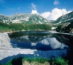
Murododaira, a lava plateau, is at an altitude of 2,450m, where Alpine plants such as Lilium medeoloides bloom in the summer. Mikurigaike Pond was created by an eruption 50,000 years ago, and Tateyama Mountain Range is reflected on the azure water surface where the snow melted.
The Tateyama Mountain Range’s orogeny movement had created a variety of topographical landscapes. The unrealistic scenery of Jigokudani Valley, which is a world where nothing lives, captures the heart. There is the history of the mountain worship.
This high land spreads across Yamanouchi Town Nagano. It is a short trip to Mt. Ryuosan by the ropeway. There is a walking path with a wetland in standing trees, after going to deep in the mountain. When you walk along this path, you will come across a lovely and fantastic Alpine flower garden and a vivid landscape, with numerous animals and plants.
About 6 km along the forest road, along the Shirasawa River, there is a waterfall that creates fresh air, with white splashes in front of you.
Gosen City is surrounded by Suganadake, Okurayama and Narusawa Mountain Ranges, which arose from the Agano River. The Agano River runs through Niigata City to the Sea of Japan. The beech virgin forests and the giant Japanese Judas trees vegetate on the mid slopes of Mt. Suganadake and Mt. Okurayama.
There is the sacred mountain, Mt. Echigo Hakusan at the southern end of Gosen City. The underground water of Mt. Echigo Hakusan is known as “Tengu no Shimizu,” the water prepared for a famous brand of sake.
The Hayade River flows through the west end of the mountain ranges, which has a beautiful gorge in the upper stream. The gorge in autumn colors is wonderful!
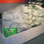
“The Islands sunk down and floated up ” —Twenty million years ago, Fossa Magna, a 6,000 meter deep land fissure that split Eastern and Western Japan, was created at the border of the Eurasia and the North American continental plates. 700,000 years ago, that fissure was lifted by those plates and connected the Islands. This museum is a stone museum at Nunakawa no sato in Miyama Park Itoigawa City.
It is directly above the Itoigawa Shizuoka Tectonic Line on the west side of the Fossa Magna (Great Rift in Latin) in the Central Rift Zone. They exhibit precious stone specimens including large jade ore. About 500 million years ago, jade was considered a precious stone of ancient amulets, and it was supplied to the east and west of the Japanese archipelago by a maritime network.
: the Fossa Magna was founded by Dr. Heinrich Edmund Naumann (1854 – 1927), a German geologist and teacher of Oyatoi Gaikokujin, the foreign employees in Meiji Japan.
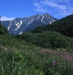
The Shirouma Mountain Range is in the northernmost part of the Japanese Alps. Mt. Hakubadake, with an altitude of 2,932m, is one of Shirouma Sanzan, the three mountains: Mt. Hakuba-Yarigatake, Mt. Shakushidake, and Mt. Shiroumadake. Mt. Shiroumadake has a mountain shape with different slopes on both sides of the ridge line, which extends north to south, and is a reservoir of Alpine Plants.
You can go to the Happo One Nature Trail, by changing gondola lifts, where you can climb to enjoy the force of the mountains approaching. You will eventually reach Happpouike pond with an altitude of 2,060m, which was formed by the accumulation of earth and sand. You feel that life is a natural structure that has been circulating since ancient times.
Fujimidai Highland is located at the northern part of Mt. Ena, which is the prefectural border between Achi Village in Nagano prefecture and Nakatsugawa City in Gifu prefecture. It is a highland, covered with ground bamboo grass. It was originally called Mt. Yamabushitake – the mountain of Yamabushi: mountain ascetic practice. You can go to the 7th station of Fujimidakikogen by ropeway.
The Mikasa Pass is located nearby, which has been said to be the hardest part of Tosan-do Road, an ancient division of the country and the main road running through it. It was situated along the central mountains of northern Honshu, Tohoku region, in ancient times.
The view of Fujimidaikogen remains the same as the view the ancient men saw, as they traveled far from Nara Capital, stopped there, and praised the scenery after passing by.
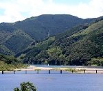
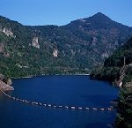
This Quasi-National Park spans Niigata and Fukushima prefectures. The unexplored region of Okudami is a spectacular view and the gateway to Ozenuma Pond. The source of the Tadamigawa River is Ozenuma Pond, which flows west.
The artificial lake, Okutadamiko Lake has a forest of beech, which is widely distributed on the Sea of Japan side and is said to have great healing power, due to its capacity to hold water.
The artificial lake of the site used to be the silver mine of the Shogun demesne in the Edo period (1603 – 1868). It is also called Ginzan Lake –silver mine lake.

The Kurobe Gorge is a deep V-shaped gorge that rises in the upper and middle reaches of the Kurobe River. It originated from Mt. Washibatake in the central part of the Northern Alps. The trolley railway began in 1937, with the development of power resources in the Gorge. Since then, it has been crowded with people who have been fascinated by the unexplored region.
Maeda Tsunanori (1643 – 1724), the 4th lord of the Kaga Domain, made the Aimotobashi Bridge, on the Kurobe River, which was one of three unusual bridges in Japan. The part of the restored model of the Aimotobashi Bridge is exhibited at Kurobe City Museum of History and Folklore. It conveys the history of regional innovation.
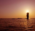
Kasa no misaki, a Cape that protrudes toward the Sea of Japan on the Kaga coast. It is a sea cliff with large and small islets scattered at the tip of the cape and a perfect scenic spot to open to the Sea of Japan to the left and right. The contrast between the chalky light house and the azure sea is beautiful.
Depending on its geography and topography, this cape was also a relay station for Kitamae-bune, cargo ships that sailed the Japanese Sea, between Ezo, Hokkaido and Osaka, during the Edo period (1603 – 1868), and the Meiji period (1868 – 1912). The townscape of Hashidate Town, was created by the wealthy trading where the shipowners’ houses were lined up.
The algae diatoms, which existed since the Jurassic period (199.6 million to 145.5 million years ago), about 180 thousand years ago, had fossilized and turned into soil. The Strange rock of Mitsuke Island (Height 28m) is entirely made of silica soil. Silicon earth has been used in earthenware, since ancient times, because it was easy to produce and baked at a relatively low temperature.
Silicon earth has a large amount of infrared emission, which can burn into foodstuffs. Then, Kiridashi Hichirin, a portable clay cooking stove, made of a lump of diatomaceous earth, was commercialized in the Showa period (1926 – 1989).
Mikata Goko Lakes, 5 lakes – Mikatako Lake, Suigetsuko Lake, Sugako Lake, Hirugako Lake, and Kugushiko Lake, are in the valleys of the low mountains, and create a mysterious tone of color. They are a scenic spot, representing Wakasa Wan Quasi-National Park, which was also described in Manyoshu, the 8th century anthology of Japanese poetry.
About 20,000 years ago, people settled in the inland lake, far from the coast, just before the Jomon period (16,000 years ago – 3,000 years ago). The ancient culture going up to the north, along the sea road, took root in the landscape that was created by repeated fault changes.
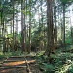
This forest is the birthplace of Japanese forest bathing and it is the site of the reconstruction resource of the Jingu, Ise Shrine. In the ancient and Middle Ages, it was a forest for the Imperial Court and the Shogun recommended a temple be built.
In early modern times, Toyotomi Hideyoshi (1537-1598), chief advisor to the Emperor, owned this forest and used the construction of Jyurakudai, his residence and office in Kyoto, and Fushimijo castle, for his wife.
Until the order of forest protection by Owari Tokugawa Domain in 1665, deforestation continued for the construction of Edo Tokugawa Shogun castle and Nagoya Owari Tokugawa castle, using the Kiso river and Hida river for delivery.

Nabedaira Kogen is at an altitude of 1,300m. On the nature trail surrounded by the natural forests of beech and Mongolian oak, wild grasses, and others, and flowers in Oku Hida, you can enjoy the magnificent scenery of the Northern Alps.
This visitor center hall has mountain video footage and a searchable model of the mountain. They also hold various events, such as a walking tour, led by a visitor center guide and snowshoe tours in the winter, along the nature trails.
Wakasa Obama is located in the middle of the Japan archipelago on the Japan Sea side. It is a “food country” that had offered the Emperor’s food since the Nara era (710-794). It flourished as a important place for maritime traffic to the China continent and Korean peninshula, and was deeply connected to the capital of Kyoto on the Saba(Mackerel) road, and has handed down many festivals and performing arts.
The Sotomo Scenic Coastline on the north side of the Uchitomi Peninshula is a magnificent landscape to guard trade ships from ancient times.
Mt. Yatsugatake in the summer has low humidity and cool temperatures. It is the home to rich wildlife, such as wildflowers and wild birds. This ropeway extends over Mt. Kitayokodake, with an altitude of 2,472m, and the Anbu, a saddle-shaped depression in the mountain ridge of Mt. Shimagareyama, with an altitude of 2,403m, in the area of Mt. Kita-Yatsugatake, northern Yatsugatake. You can see Fir wave, from the ropeway.
The stripe shaped pattern appears by the metabolism of life of Veitch’s silver fir and Maries’ fir, which occurred over the cycle of 100 years. Mysterious time can be seen as a pattern!
In the Shinshu Nagano basin, the water temperature is higher than the air temperature, so fog tends to occur along the river. The fog also makes the landscape mysterious. Obaste Chikuma city is a famous spot for the moon. The famous moon from Mt. Kyodaisan, on the other side of the river, and “Tagoto no Tuki: the moon reflected in several rice-fields lying in tiers on a hillside”, comforted the hearts of the people, since ancient times.
The magnificent view also became a poem by Matsuo Basho (1644 – 1694), the most famous poet of the Edo period. The night view along the Chikuma River extends to Zenkoji daira, a basin, under the stars in the sky.
Tenryu River Rafting goes down, with the excellent oaring, along the violent segment of the Tenryu River, which pours into the Pacific Ocean, from Suwa Lake, through Inaya. You sail down the odd sight of Tenryukyo Gorge, which is reminiscent of landscape paintings, with the towering cliffs and strangely shaped rocks on both sides of the river.
From the boat, you can see Tenryukyo Jyusho – 10 strangely shaped rocks in Tenryukyo Gorge, such as Ryukakuho, which is said to be the incarnated rock of the dragon that lived in the river, when it flew to heaven. When you look up the narrow and high skies of the gorge, you can feel the sensation of a fairyland.

Onumaike Pond is at the foot of Mt. Shigayama, with an altitude of 2,035m, which is located deep in the mountains of Shigakogen Highland in Yamanouchi Town, Nagano Prefecture. The lake water is dammed by the lava flow of Mt. Shigayama. It is highly transparent and shines cobalt blue.
On the lakeside, flowers of Japanese mustard spinach and Hiogiayame, an original species of iris, sways in the wind. On the mountain trails, the virgin forest of Maries’ fir grows. The Highland is the reservoir of nature. You can also enjoy the feeling of highbrow sightseeing, far away from the city.
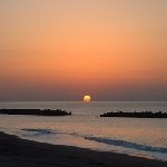
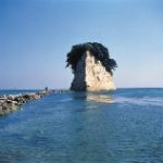
This area is a scenic spot, mentioned in the railway song, “The best view of the sea in Japan is Gamagori”. A western-style inn and attached Japanese style restaurant, Tokiwa House, was built in a perfect location, on the opposite shore of Takeshima Island, at the end of the Meiji period (1868 – 1912). From here, you can only see Takeshima Island and the blue sea. Many writers and artists visited here who was attracted by the extraordinary view and weaved into their work the rustic beauty of the the sea in Gamagori and Takeshima Island.
This memorial hall presents and introduces literary people and writers, who received the writing and drawing power from Takeshima Island. Takeshima Island, a 680m granitic island, is connected to the land by the Takeshima-bashi, the bridge of Enmusubi, a match-maker. The vegetation of trees in this island is different from the opposite shore, with over 200 species of plants.
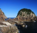
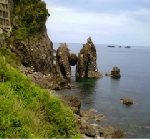
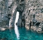
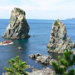
Tategasaki Sightseeing Boat Tour goes around the Kumano-nada Sea in the eastern part of the Kii Peninsula, on a one hour tour. The magnificent coastal beauty created by rough seas can only be enjoyed from the sea.
The “Taegasaki” is a large rocky wall with a height of about 80m and a circumference of about 550m, which stands like a huge shield with a large number of pillars piercing the sea.
This rock wall of Columnar Joint rock is characteristic of the coast of Kumano and has been a subject of worship since ancient times.
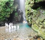
This gorge is located at the upper reaches of the Tado River, which flows from Mt. Tado, with an altitude of 403m, at the prefectural border of Mie and Gifu. You can enjoy the colorful seasons with fresh green in spring and autumn leaves.
Near the Midorigaike pond, the natural monument “Inunashi,” the ancestor of a pear, grows naturally and blooms in the middle of April. Genji fireflies, Luciola cruciate, appears in the middle of June.
And in the summer, Tado Gorge becomes a natural pool! It has a depth of 80 cm and a water temperature of 20 degrees, and is a dam of the Tado River.
Mikuni Town is the mouth of the Kuzuryu River that pours into the Sea of Japan. It had flourished as an active port for a long time, including the Trade, of Kitamae-bune, cargo ships that sailed the Japanese Sea in between Ezo, Hokkaido and Osaka, in the Edo period (1603 – 1868). The atmosphere of Tojinbo, a scenic spot, famous for its series of rugged precipitous cliffs as high as 25m, is in the contrast with that of Mikuni Town.
And Echizen Coast is the coastline from Tojinbo to Suiz in Tsuruga City, via Cape Echizen. The scenic beauty of the rocks broken into columns and eroded by the rough seas of the Sea of Japan continues.
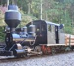
In 1916, a forest railway to transport timber, instead of rivers, had run through Kiso Mountains. The steam locomotive at that time was an original train of this railway. It used wood chips, instead of coal, and had a smoke tube in the style of a hat like a Moai statue. The smoke tube created a swirling air flow inside, dropping the sparks down.
After the forest was converted into a park as the first Natural Recreation Forest in Japan, the forest railway was revived as a sightseeing train. The steam locomotive is also open to the public in the park.
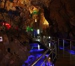
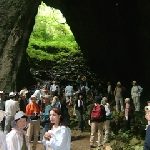
This limestone cave, with an altitude of 900m, is the highest tourist limestone cave in Japan. It was discovered in 1965 and is an amazing work of art, created by time and nature. Fossils, such as sea lily and fusulina, were found in the limestone cave.
It shows that the limestone cave might have been the bottom of the sea 250 million years ago. The coral at the bottom of the sea died and became limestone, which traveled through the bottom of the ancient South Sea, over a long, long time.
The Kishu mine is part of the Kii Kumano Copper Mine, which used to mine silver, during the Nara period (710-794). At that time, copper mining began. The Kishu mining offered copper for the Todaiji Great Buddha casting. There were up to 40 mines during the Edo period (1603 – 1868).
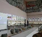
This museum exhibits the Kishu mine history from the Edo period to the Showa period (1926 – 1989), using real objects and models. This museum also has ore collected from around the world, in addition to the ore produced here at that time, including the largest piece of fluorite in Japan.

The sea of Toba was the sea where Mikimoto Kokichi (1858 – 1954), a world-famous pearl dealer, was the first to cultivate cultured, semi-circle pearls. He founded Mikimoto Pearl Company in 1893. Mikimoto Pearl Island is a habitat for wild birds, where 200 year old natural forests flourish.
The sea also has beautiful scenery where the sea firefly has shined for 400 million years. Japan has worshiped something that shines mysteriously with the moon and star lights, such as turban shells, since ancient times.
You can enjoy the scenery of the origin of Kokichi along with the history of Japan on the Toba Sea.
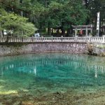
The pond is a transparent blue, unique to the karst landform, which is the mystery of the earth connecting to the deep sea. It was said that there was a rich person suffering from a water shortage. After cultivating the land, he followed the oracle in his dream and enshrined Benzaiten: Sarasvati, the god of wealth, music eloquence and water, at this pond and water sprang up.
The coral reefs in the south sea were carried to the north 350 million years ago, raised, and becoming Akiyoshidai, karst plateau. The long voyage from the south sea is told by fossils such as corals and sea lilies in limestone.
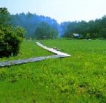
This Highland Wetland in Ikeda Town is surrounded by mountains, with an altitude of more than 600m on the east, west and north sides, and slopes gently toward the Matsuo River in the south. At the foot of the 26.7ha wetland, aquatic plants such as Sphagnum palustre, fringed orchid, shield sundew and kiseruazami, Black thistle, flourish.
At the wetland, many rare plants, such as Pogonia japonica, fringed orchid and insectivorous plant, grow in colonies. It is a fount of innocence that should be preserved.
The Shinamtogawa River is the last clear stream in Japan. It meanders through the Midwestern part of Kochi Prefecture to the Pacific Ocean. Classes for touring the river, along the 8km stretch between Ekawasaki and Iwama, are held at the Kanoue House of Shinamtogawa River Michinoeki. There, you can enjoy the nature of the Shinamtogawa River.
The Shimanto tectonic zone is the crustal structure, and the base of Shikoku Island, which has traveled with the Kuroshio, the Japan Current, from the southern seabed more than 100 million years ago. Ancient memories remain in nature.
While going down the Watarigawa River (the Shimantogawa River‘s previous name), you can feel the eternal time.
Chugoku mountains are the oldest stratum in the Japanese Islands. It is rich in granite and magnetite, created by cooling magma and weathered over the years. Magnetite turned into sand iron and was useful for Tatara, an iron manufacturing method to use iron sand.
Granite becomes white sand on the seashore, with pine trees, called “Msago,” and sand dunes. The beautiful wind ripples are also born, produced by weak winds, flows into the Sea of Japan, and return to land by tide and wind.
It is the beauty of Japan that continues to change.
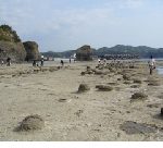
The Tatomaura area on the Togane coast of Kokubuncho Hamada City is a scenic spot that has been called Tokonoura for a long time. The Senjojiki, a 1,000 Tatami mat (1,824m2) coast, where small cracks that run vertically and horizontally can be seen.
There is the wave-cut platform with about 49,000m2 of a 16 million years old stratum, has sea cliffs and faults with spectacular conglomerates and sandstones, with a height of about 25 m.
The spectacular landscape of rock surface fused together with the Senjojiki coast and cliffs, was created by the rising sea surface.
Okinoshima Island is a volcanic island where the mountains links as centering on Mt. Daimanjisan, with a 608m peak. Rare nature remains on the island, such as a huge cedar called Chichisugi cedar, a uniquely-shaped cedar, and trees favoring warm climate.
The coastline eroded by the Sea of Japan has many cliffs, strangely shaped rocks and oddly shaped stones. Rosokujima Island (Candle Island, an Island in the shape of a candle) has a height of 20m and stands 500m northeast of Ojirohana, Okinoshimamachi-shiro.
The sun floating above the sea and strangely-shaped rocks overlap in the sunset, and illuminate a miracle of nature. – The evening sun passes the top of Rosokujima Island, and the candle has the light in some time.
Rashomon in Kusama, Niimi City is a collapsed limestone cave. The remaining upper part became a natural bridge, and the bottom of the bridge became a gate. The 2nd and 3rd gates are connected together, and the 4th gate is a hole, where rainwater is sucked underground.
Although it is with an altitude of 400m, there is rare alpine and northern bryophyta (moss), and lichens to habitate, and Notoptera, called “live fossils”, and cave insects to habitate. There is a mystery that connects to the deep sea.
This gorge is located at the part of the Tsurukisan Quasi-National Park, which is right in the middle of Shikoku Island. The rocks on both sides of the Yoshino River are natural monuments designated by the prefecture.
The best way to enjoy the unexplored region of Obokekyo Gorge is by taking the Sightseeing Boat down the river, with a history from 1891 – 1892. With a light explanation of the boatman, the sculpture beauty of the rocks, which have eroded for more than 200 million years, the autumn colors and the beauty of the fresh green are deepening.

Kankakei is a national park in Shodoshima Island, Kagawa Prefecture. There are strangely shaped rocks from violent eruptions about 1,300 years ago and have been created by wind and rain erosion. It is a place of scenic beauty where the vertically rising rock wall became nature’s ultimate sculptural beauty.
The highlight of Shodoshima Island sightseeing is the Sky-walk, by the ropeway between the rocks. The calm and peaceful sea of Seto Inland Sea spreads below your eyes. The sea was the route of civilization and culture since ancient times.
This museum opened in 1983. It opened as the first public museum in the Sanin region. Since then, this museum has been working to introduce the beauty of Yonago and to evaluate artists associated with the local area. The museum possesses more than 1,704 paintings by local artists and drawing of the rich local climate.
Kobayashi Wasaku (1888 – 1974) is a western landscape painter. He was inspired by the painting of Umehara Ryuusaburo (1888 – 1986), who learned under Asai Chuu (1856 – 1907), a Japanese painter who developed the western style of art movement in Japanese painting, and traveled by sketching the sea and mountains in various parts of Japan.
There is the work of Mt. Daisen by Kobayashi Wasaku. He captured the movement of light and the atmosphere in the spring scenery, where all living things in the mountain awaken from a long and harsh winter, by painting quickly with paints mixed roughly by a knife. It is a work of Tenchihorei: heaven and earth are buxom and beautiful.
– Mt. Daisen has been a holy mountain from the ancient times and the ancient agricultural settlements existed around Mt. Daisen.
An earthquake fossil, pseudotachylyte, is on Oshima Island in the Uwakai sea, which is designated as a national natural monument. Pseudotachylyte is the black glassy vein rocks formed by the rapid destruction of bedrock, caused by an earthquake.
There are three fault zones containing this fossil. Each fault zone has a width of 2 to 3 m and a length of about 10 to 50m. It is the largest in Japan. Pseudotachylyte is a valuable resource for knowing that the earth is alive and active.
The island is located in the Kita-nagato Kaigan Quasi-national Park, which is also known as the Sea Alps. You can fully experience the magnificence of natural art, on the sightseeing boat, where you can view the cliffs eroded by rough waves, strangely shaped rocks, and the wave works.
And, when you walk along the nature research trail, looking down on the wave works below, you can definitely get the feeling of a phrase in the poem by Kaneko Misuzu (1903 – 1930), a Japanese poet and songwriter. – The phrase is “We are all different and all wonderful”.
The summit of this mountain park has an altitude of 654m and has 360 degree panoramic views and a sea of clouds. You can see Mt. Gagyusan (Height about 480m) and Bicchu Matsuyamajo Castle from the summit. Bicchu Matsuyamajo Castle is the highest mountain castle with a tower in Japan, which was renovated and reconstructed by Kobori Enshu (1579 – 1647), a feudal lord, a master of the tea ceremony, an architect and garden designer, and his son.
The history of Mt. Yatakayama started 2.5 million years ago. The rocks were hard and this mountain remained after many years of erosion. The view let you feel a fount of innocence to evoke emotions.
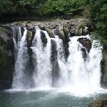
Todoroki Kujudaki Water Falls are one of the leading waterfalls in Shikoku Island and are at the upper reaches of the clear stream of the Kaifugawa River. Hontaki, the main water fall, with a drop of 58m, was selected as one of the 100 most famous waterfalls in Japan. There are various waterfalls of various sizes at the upper reaches of Hontaki, such as Nijunotaki Water Fall, Fudo Water Fall, Yokomi Water Fall, and Torikaeshi Water Fall.
In the summer and autumn, the ritual of Mikoshi, a portable shrine entering the waterhole of Hontaki, is held to worship the whole water fall as the object enshrined. It is also the origin of the mysterious Kaifu Sword that has been transmitted since ancient times.
Mt. Tsurugi (height 1955m) is the second highest peak in Shikoku Island. You can reach the summit in 15 minutes by lift or 40 minutes on foot from Minokoshi, a main mountain entrance. At the summit, you can see the Yoshino River, nicknamed Shikoku Saburo below, Mt. Daisen, Totori to the north, over the Seto Inland Sea, and Kii Mountains to the east. The summit is a flat grassland called Heike’s Baba, a riding ground.
It was said that the name of this mountain came from the sword of Sanshu no Jingi, the three sacred treasures of the Japanese Imperial Court – Sword, mirror, and ornamental bead. The sword disappeared, along with the Emperor Antoku (1178 – 1185), which helped the Heike (Taira) clan assume the throne.
This coast is a Rias coast that continues for about 15 km and is one of the most scenic spots in the Sea of Japan. The rough scenery of the cliffs eroded by the rough waves, wind and snow of the Sea of Japan creates a spectacular contrast with the gentle beaches of seawater and a beautiful stretch of sandy seashore dotted with pine trees.
It is like the scenery of Horaisan, the treasure mountain island in Japanese mythology, which was drawn by Makie, a lacquer decoration sprinkled with metal powder, from the Heian period (794 – 1185).
A promenade is maintained along the coast, and the view especially on the coast from Ajiro Coast to Tajiri Coast, was highly praised by Shimazaki Toson (1872 – 1943), a Japanese author, as “Matsushima ha Matsushima, Uratomi ha Uratomi – the Scenic spots of Matsushima in Miyagi, and Uratomi in Tottori, each has a beauty that is special, but not equal.”
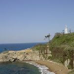
A chalky Light House on the cliff of Cape Ashizuri protrudes into the Pacific Ocean. It has been lit for safe navigation since in 1914. In the Medieval Ages, the cape was thought to be the site of the east gate leading to Mount Potalaka in the seas south of India, the mythical dwelling of Kannon: the Buddhist Goddess of Mercy, and was worshipped.
It is said that Kobo Daishi Kukai (774 – 835): the founder of the Shingon sect, founded Kongofukuji Temple in 822, when Emperor Saga (786 – 842) gave Kukai an Imperial scroll of “Fudaraku Tomon – the east gate leading to Mount Potalaka” written by the Emperor himself.
The view might overlap the tide of life and consciousness in East Asia moving northward like a dream of Kukai.
– Kukai brought Shingon Esoteric Buddhism to Japan, via an envoy ship from the Tang Dynasty (618 – 907).
This lake is in the center of Tottori prefecture, which is called Tsuru no Umi – the crane-shaped lake, and is one of Eight Views of Sanin region – Tottori, Shimane, and Yamaguchi Prefectures. It is a brackish lake with a circumference of 12 km and a depth of 2 to 7 m, which leads to the Sea of Japan. Seawater flows backwards in the summer, so there are plenty of Japanese pond smelt, icefish, carp, crucian carp and eel.
The Yotsude Ami, a four-armed scoop net of fishing gear, stretched out at the four corners of the net with bamboo, is the symbol of this lake side, which is pulled up from a hut on the lake shore by pulleys to catch shrimp, Japanese pond smelt and icefish.
Oki Island was part of the Sanin region of Honshu Island until about 20,000 years ago. During the Ice Age, the plant – northern species such as Oki rhododendron, continental species such as touteiran, and southern species such as nagoran, had migrated to Oki Island.
In the sea, by the warm current of the Tsushima Strait, southern fish such as Japanese pinecone fish, and reef building coral of northern limit can be seen.
This museum exhibits the specimens of a finite life and infinite memory in the Oki Islands and the sea of the National Park, which have crossed the north-south boundary line.
The Nakayama River originated from the submarine valley of the Ichizuchisan Mountain Range. There is natural treasure, the exposure of the thrust fault, on the left bank of the lower reaches, from Kurumi Bridge. This Gorge is the Median Tectonic Line that crosses the Japanese archipelago. The exposure occurred from the strong pressure from the north, millions of years ago.
There is the tunnel, Hekigantosuiro in the middle of a major fault on the Median Tectonic Line, which was an irrigation canal and was made with only chisels and hammers over the course of 9 years, in the Edo period (1603 – 1868). It is praised as “Ao no Domon in Iyo province Ehime ”
– Ao no Domon is the Blue Tunnel in Yabakei Gorge, a scenic place of beauty in Nakatsu Oita.
350 million years ago, the submarine volcano had been born on the old Pacific Ocean near the equator, and coral reefs were formed near the sea surface. The submarine volcano and coral reef group moved north, due to the movement of the Sea Plate, reached the Eurasia Continent, and formed the limestone layer.
The crustal movement called the Akiyoshi Orogenic Movement, had raised the stratum of limestone layer as part of the mountain range. That was the birth of the limestone plateau, Akiyoshidai.
This museum introduces well the eternal journey in an easily understandable way.
You can see the views of the lush mountain greenery and the tranquil rural scenery at the foot of the mountain in Miyawaka City, which used to be the domain of Munakata Taisha Shrine, since the Taika Reforms in 645, political innovations led by Prince Nakanoue (Emperor Tenji) (626 – 672), and Furiwara Kamatari (614 – 669), against the powerful Soga clan, to extend the direct dominion of the Emperor’s family over the whole of Japan. It is a beautiful green village, due to the graceful water from the mountains.
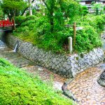
Rakusuinomichi Promenade is a 500m promenade that uses natural stones along the Inunakigawa River, between the Zasunosebashi Bridge and the Wakitabashi Bridge in Wakita Onsen, hot spring. The refreshing breeze and the quiet murmuring of the stream makes you feel at ease.
This wetland is registered under the Ramsar Convention. The colony of little sphagnum, juncus fauriei, marsh marigold and lobelia sessilifolia grow, and grassland birds such as Hoaoka, a chestnut-eared bunting and Secca, a fan-tailed warbler breed.
Great tit and long-tailed tit in the forest and Japanese white-eye in the river can be observed. Grey wagtail and brown dipper inhabit. Mammals such as small Japanese field mice also inhabit.
These living environments are maintained by burning the grass before spring.
Mt. Gozendake, located on the prefectural border between Yame Fukuoka, and Hita Oita, is an ancient sacred mountain, which is associated with Kumaso, a tribe living in the ancient Kyushu district. The tribe was seized by Emperor Keiko, the son of Prince Yamato Takeru, in his conquest of local tribes in Japan. Japan General Guardian of Oyamatsumi no mikoto: a god of mountains, sea and war in Japanese mythology. Mt. Gozendake is famous as the virgin forest of Shioji, ash, too.
You can find many springs coming from Mt. Gozendake within a 30 minute walk from the start of the mountain trail. The water has an abundance of minerals and is one of Oita Prefecture’s most famous waters, along with Oike pond in Yufu City.
This wetland is a mountainous intermediate wetland that was created in the Kuju mountain range and has the wetland largest area in Japan. It is a wetland registered under the Ramsar Convention along with Kujubo Gatsuru.
he dominant species are reeds, Moliniopsis japonica, and Japanese pampas grass. The low tree forest of Hydrangea paniculata and Japanese black pine are found in colonies, and rare plants are seen, such as Tsukufuuro: Geranium soboliferum var. kiusianum, Shimuraninjin, Pterygopleurum neurophyllum, and Sphagnum palustre.
You can freely walk down the nature research road.
This Gorge is located in the upper reaches of the Kuwabaru River. It is a clear stream from Mt. Natsukiyama of the Sobo-Katamuki Mountain Range, which rises at the prefectural border of Oita and Miyazaki.
Various potholes carved, such as bunodont, spiral and gourd-shaped follow for 8km distance from the water source of Kanondaki Water Fall to Fujikawachi village.
The Kanoundaki Water Fall is a big waterfall in 77m high and 2m wide. The red granite wall of the water fall shines in the sunset, and the frozen wall in the winter reflects the morning sun.
Arita Town is a town surrounded by Mt. Kurokamiyama. There is Ryumonkyo Gorge at the start of the mountain trail, where you hear the singing of Kajika frog, a Japanese singing frog. The mountain stream is at the top of the list of one hundred Famous Waters.
The 400 years history of Arita ware as the first porcelain in Japan, spurred the development of high quality pottery stones. The no fade beauty of Arita ware has the integrity and the vibration of Ryumonkyo Gorge inside. The origin of its beauty comes from the Gorge.
Miyakonojo City is a basin surrounded by the Kirishima Mountains to the west and the Wanitsuka Mountains to the east. At the end of the season, a mountain fog arrives in the basin and a magnificent sea of clouds appears from Mt. Kanemidake.
Sekinoo Falls, is one of Japan’s Top 100 Waterfalls, which was formed by the collapse of a river that eroded the welded tuff created by a large eruption about 330,000 years ago. The splash that rises with the roar is just the rare energy that throbs now.
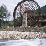
A huge water wheel, with a diameter of 18.18m is located at the upper reach of the Banjogawa River, which is one of the clearest streams in Kyushu Island. There were many water wheels that were used as a power source for agricultural work.
Now, only this huge water wheel is reproduced at the campsite in this park, fits well with the scene of nature, and creates a rhythm. And this rhythm lives with nature.
It gives new ties, when you visit this campsite and spend time.
Mt. Asosan became a mother of stone culture of Kyushu Island by carrying a repeated, pyroclastic flow of large eruptions throughout Kyushu Island for 90,000 years. Using the museum’s Mt. Aso walking guide, you can meet Mt. Aso, still alive from Mt. Nakadake to Sunasenrigahama, overlook the view of the caldera spreading from Mt. Daikanbo to Gairinzan, the outer rim of a crater, and stroll the meadow around Kusasenrigahama and Mt. Komezuka.
You can feel the wonder of nature by seeing the water that springs out from Shirakawa Water Source at Minamiaso Village.
There are two mysterious streams in a national park taken hold by Mt. Kirishima. From November to April, the Mitaaraigawa River is mostly dry, and starts to spring out water around May, and the Ryodogawa River starts to spring out water in June. It becomes dry around August and September. Both rivers are extremely clean and abundant.
The mysterious streams have been loved as a reservoir of nature, and the water source is gracefully changing deep underground in Mt. Kirishima.
The mysterious gorges endlessly extend to the upper stream of the Yufugawa River. Kinrin Lake is at the foot of Mt. Yufudake, where the hot springs and clear water springs come together, from the bottom, which is the head of the Oita River. It is famous for the morning mist. A Torii, a gateway at the entrance to a Shrine, floats on the fantastic lake where steam rises. The surface of the lake changes color, part by part, and you can see a beautiful Konara oak, a virgin forest, behind the lake.
There is a history of Busanji Temple, which enshrines Susano-no-Mikoto, the younger brother of Amaterasu Oomikami: Sun Goddess and the Japanese Emperors are considered to be direct descendants of Amaterasu, and a local deity linked with harvest and agriculture.
Susano-no-Mikoto has the extermination legend of a large snake (- In Japan, a large snake used to be the symbol of the lava flow from an active volcano). And Busanji Temple is the guardian deity of Mt. Yufudake.
Aso is a caldera (nabe) formed by a large, repeated eruption, approximately 90,000 years ago. The Shirakawa water source, which is enshrined at the Shirakawa Yoshimi shrine and belongs to the Aso shrine, springs 60 tons of water every minute.
A lot of Rainwater is stored in the basement of Aso and springs up over time.This water makes the Shirakawa River and joins the Kurokawa River in the Aso Basin. This water enriches the Higo Plain and reaches the Ariake Sea.
This spring water is soft water and keeps at 14 degrees Celsius. The taste of it is delicious.
This park is the famous spot for autumn colors in Saga Prefecture, between Furuyu Onsen, hot spring, and Kumanokawa Onsen.
Mt.Tenzan, with an altitude of 1,046m, belongs to the Tsukushi Mountains on the southern end. Mt. Sefurisan, at 1,055m, is adjacent to Fukuoka Prefecture at the northern end. Mt. Tenzan and Mt. Sefurisan link and supply a rich clear stream, which made the beauty of this Gorge through the power of erosion.
Thickly growing trees and beautiful, strangely shaped rocks, and mysterious caves, are enhanced by the vermilion-painted Narusebashi Bridge, which is like Akaetsuke, a porcelain decorated in a colorful over-glazed design.
Mt. Takachihonomine (1574m) was an object of worship since ancient times. Kirishima shrine used to be located at the foot of the mountain and was burned frequently by eruptions. Shoku Shonin (910-1007), a High Priest of the Tendai sect of Buddhism, belonging to Mountain Buddhism, moved this shrine to Takachihogawara (970m) in the Heian period.
There is a beautiful vermilion- lacquered shrine built in 1715 by Shimazu Yoshitaka (1675-1747), the lords of the Satsuma clan, Kagoshima, after passing through an approximately 800-year-old sacred cedar tree, which is the ancestor of a cedar tree in South Kyushu Island.
The Gagaku, Japanese court music that came from Kagura, and Formal Ritual Dancing at the Imperial Palace has been inherited from this shrine.
Ryukyu arc is approximately 1,260 km off the coast of Kyushu Island in the Japanese archipelago, such as the Nansei Islands and the Ryukyu Archipelago, where 199 islands dot like the edge of flower. The Ryukyu Arc has tall forested islands and flat islands with clear water springs. Yakushima is a tall forested island.
Shiratani Unsuikyo Ravine is in the branch of the Miyanoura River, floating in the northern part of the island. It was formed from eroding granite from the rich rains and is covered by virgin forest.
The scenery is the original landscape in the Japanese archipelago, from the Jomon period (16,000 years ago – 3,000 years ago).
Yame is the place where the Yabe River and the Hoshino River meet, from the border of Oita Prefecture. It has been an alluvial fan, filled with natural benefits since ancient times. Today it is one of the best tea producing areas in Kyushu Island. When the clear stream Yabe River takes a sunset, the memory of the ancient time strolls all over the field of the tea plantations.
Tsukushino kimi Iwai (died 528) was a powerful family and regional administrator in Tsukushi Province, Fukuoka, who became the king who revolted against the Imperial court. -The history has been left by the winner. The evidence tells the fact.
The fact that the tomb of Tsukushino kimi Iwai has been preserved quietly tells you his legitimacy.