

The Kitayamagawa River flows to Kumano-nada Sea from Mt. Odaigahara, which is one of the world’s rainiest areas. Dorokyo Gorge extends for about 31km. It’s beauty had been created from erosion. You can enjoy the magnificent scale of natural sculptural beauty by driving to the place, Doryokyo Meguri no Sato Kumanogawa Shiko, which has been revived with many restaurants and souvenir shops.
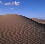
This park spans approximately 75km from the Amino Coast of Tango Peninsula to the Tottori sand dunes. It consists of sea-cliff terrain, cave entrances, beach terrain, and the Kyotango Kumihama Coast. Both are the oldest stratum in the Japanese archipelago, and are from rocks raised above the seabed, containing a large amount of iron.
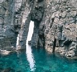
Hasakariiwa Rock at the Takeno Coast was sandwiched between the rocks on the side walls as the ceiling rock tried to fall into the sea. The dunes represent the time of migration and this rock represents the time of immobility.
The area of approximately 110 km east to west of Kyoga Cape, Kyoto Prefecture, and the Hakuto Coast in Tottori prefecture, has a variety of coastal landforms such as Rias coasts and sand dunes, created with igneous rocks and stratum. Sea level changes and crustal movements contributed to the formation of the Sea of Japan, 25 million years ago.
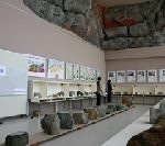
The center exhibits a model explaining the stratum on the Sanin Kaigan, coast, and Geoheritage – basalt, andesite, and tuff of geo-site in the area. The center also supports learning of geo-site.
The algae diatoms, which existed since the Jurassic period (199.6 million to 145.5 million years ago), about 180 thousand years ago, had fossilized and turned into soil. The Strange rock of Mitsuke Island (Height 28m) is entirely made of silica soil. Silicon earth has been used in earthenware, since ancient times, because it was easy to produce and baked at a relatively low temperature.
Silicon earth has a large amount of infrared emission, which can burn into foodstuffs. Then, Kiridashi Hichirin, a portable clay cooking stove, made of a lump of diatomaceous earth, was commercialized in the Showa period (1926 – 1989).
Wakasa Obama is located in the middle of the Japan archipelago on the Japan Sea side. It is a “food country” that had offered the Emperor’s food since the Nara era (710-794). It flourished as a important place for maritime traffic to the China continent and Korean peninshula, and was deeply connected to the capital of Kyoto on the Saba(Mackerel) road, and has handed down many festivals and performing arts.
The Sotomo Scenic Coastline on the north side of the Uchitomi Peninshula is a magnificent landscape to guard trade ships from ancient times.
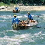
Tenryu River Rafting goes down, with the excellent oaring, along the violent segment of the Tenryu River, which pours into the Pacific Ocean, from Suwa Lake, through Inaya. You sail down the odd sight of Tenryukyo Gorge, which is reminiscent of landscape paintings, with the towering cliffs and strangely shaped rocks on both sides of the river.
From the boat, you can see Tenryukyo Jyusho – 10 strangely shaped rocks in Tenryukyo Gorge, such as Ryukakuho, which is said to be the incarnated rock of the dragon that lived in the river, when it flew to heaven. When you look up the narrow and high skies of the gorge, you can feel the sensation of a fairyland.
Chugoku mountains are the oldest stratum in the Japanese Islands. It is rich in granite and magnetite, created by cooling magma and weathered over the years. Magnetite turned into sand iron and was useful for Tatara, an iron manufacturing method to use iron sand.
Granite becomes white sand on the seashore, with pine trees, called “Msago,” and sand dunes. The beautiful wind ripples are also born, produced by weak winds, flows into the Sea of Japan, and return to land by tide and wind.
It is the beauty of Japan that continues to change.
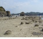
The Tatomaura area on the Togane coast of Kokubuncho Hamada City is a scenic spot that has been called Tokonoura for a long time. The Senjojiki, a 1,000 Tatami mat (1,824m2) coast, where small cracks that run vertically and horizontally can be seen.
There is the wave-cut platform with about 49,000m2 of a 16 million years old stratum, has sea cliffs and faults with spectacular conglomerates and sandstones, with a height of about 25 m.
The spectacular landscape of rock surface fused together with the Senjojiki coast and cliffs, was created by the rising sea surface.
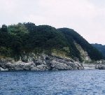
Okinoshima Island is a volcanic island where the mountains links as centering on Mt. Daimanjisan, with a 608m peak. Rare nature remains on the island, such as a huge cedar called Chichisugi cedar, a uniquely-shaped cedar, and trees favoring warm climate.
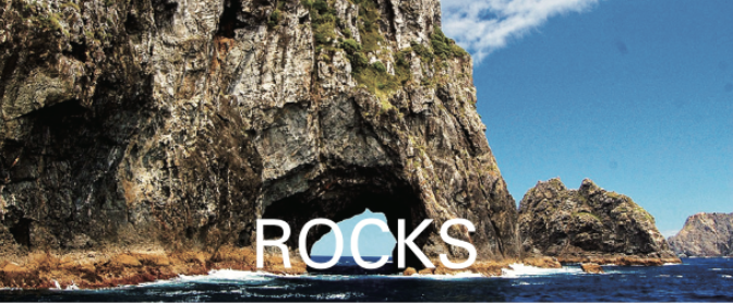
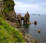
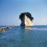
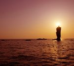
The coastline eroded by the Sea of Japan has many cliffs, strangely shaped rocks and oddly shaped stones. Rosokujima Island (Candle Island, an Island in the shape of a candle) has a height of 20m and stands 500m northeast of Ojirohana, Okinoshimamachi-shiro.
The sun floating above the sea and strangely-shaped rocks overlap in the sunset, and illuminate a miracle of nature. – The evening sun passes the top of Rosokujima Island, and the candle has the light in some time.
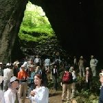
Rashomon in Kusama, Niimi City is a collapsed limestone cave. The remaining upper part became a natural bridge, and the bottom of the bridge became a gate. The 2nd and 3rd gates are connected together, and the 4th gate is a hole, where rainwater is sucked underground.
Although it is with an altitude of 400m, there is rare alpine and northern bryophyta (moss), and lichens to habitate, and Notoptera, called “live fossils”, and cave insects to habitate. There is a mystery that connects to the deep sea.
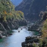
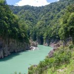
This gorge is located at the part of the Tsurukisan Quasi-National Park, which is right in the middle of Shikoku Island. The rocks on both sides of the Yoshino River are natural monuments designated by the prefecture.
The best way to enjoy the unexplored region of Obokekyo Gorge is by taking the Sightseeing Boat down the river, with a history from 1891 – 1892. With a light explanation of the boatman, the sculpture beauty of the rocks, which have eroded for more than 200 million years, the autumn colors and the beauty of the fresh green are deepening.

Kankakei is a national park in Shodoshima Island, Kagawa Prefecture. There are strangely shaped rocks from violent eruptions about 1,300 years ago and have been created by wind and rain erosion. It is a place of scenic beauty where the vertically rising rock wall became nature’s ultimate sculptural beauty.
The highlight of Shodoshima Island sightseeing is the Sky-walk, by the ropeway between the rocks. The calm and peaceful sea of Seto Inland Sea spreads below your eyes. The sea was the route of civilization and culture since ancient times.
An earthquake fossil, pseudotachylyte, is on Oshima Island in the Uwakai sea, which is designated as a national natural monument. Pseudotachylyte is the black glassy vein rocks formed by the rapid destruction of bedrock, caused by an earthquake.
There are three fault zones containing this fossil. Each fault zone has a width of 2 to 3 m and a length of about 10 to 50m. It is the largest in Japan. Pseudotachylyte is a valuable resource for knowing that the earth is alive and active.