


The museum’s possessions trace the genealogy of modern Japanese painting. It’s possessions also trace painters of the literary school in the early modern times in Japan. These came from the cultural salon of Ikeno Taiga (1723 – 1776), a Japanese painter and calligrapher, Yosa Buson (1716 – 1784), a Japanese poet and painter of the literary school, and beginning with Gion Nankai (1676 – 1751), a Japanese Confucianist, author and painter of the literary school.
These works have a common approach – they let the mind stroll with the mechanism of nature and beauty, with the knowledge from abroad and from overseas. The journey through the beauty at this museum is another Pilgrimage to the three main Kumano shrines.
This refreshing garden is located at the top of Mt. Maya, which was named by Kobo Daishi Kukai (774 – 835), the founder of the Shingon sect, for the enshrined statue of Queen Maya, the Mother of Buddha, at this mountain. This mountain was also named Hashumine, the ridge that overlooks 8 provinces, where Shugendo, Japanese mountain ascetic practices have taken place, since ancient times.
The historic site of the ascetic practices remains in the garden, too. Nunobiki no Taki originated from this garden. It was praised as a famous mineral water by the ocean-going ship of a port of call to Kobe, after opening the port.
This observation garden combines the diversity of nature with the historical and cultural heritage.
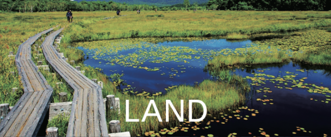
Gosen City is surrounded by Suganadake, Okurayama and Narusawa Mountain Ranges, which arose from the Agano River. The Agano River runs through Niigata City to the Sea of Japan. The beech virgin forests and the giant Japanese Judas trees vegetate on the mid slopes of Mt. Suganadake and Mt. Okurayama.
There is the sacred mountain, Mt. Echigo Hakusan at the southern end of Gosen City. The underground water of Mt. Echigo Hakusan is known as “Tengu no Shimizu,” the water prepared for a famous brand of sake.
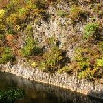
The Hayade River flows through the west end of the mountain ranges, which has a beautiful gorge in the upper stream. The gorge in autumn colors is wonderful!
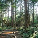
This forest is the birthplace of Japanese forest bathing and it is the site of the reconstruction resource of the Jingu, Ise Shrine. In the ancient and Middle Ages, it was a forest for the Imperial Court and the Shogun recommended a temple be built.
In early modern times, Toyotomi Hideyoshi (1537-1598), chief advisor to the Emperor, owned this forest and used the construction of Jyurakudai, his residence and office in Kyoto, and Fushimijo castle, for his wife.
Until the order of forest protection by Owari Tokugawa Domain in 1665, deforestation continued for the construction of Edo Tokugawa Shogun castle and Nagoya Owari Tokugawa castle, using the Kiso river and Hida river for delivery.
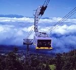
Mt. Yatsugatake in the summer has low humidity and cool temperatures. It is the home to rich wildlife, such as wildflowers and wild birds. This ropeway extends over Mt. Kitayokodake, with an altitude of 2,472m, and the Anbu, a saddle-shaped depression in the mountain ridge of Mt. Shimagareyama, with an altitude of 2,403m, in the area of Mt. Kita-Yatsugatake, northern Yatsugatake. You can see Fir wave, from the ropeway.
The stripe shaped pattern appears by the metabolism of life of Veitch’s silver fir and Maries’ fir, which occurred over the cycle of 100 years. Mysterious time can be seen as a pattern!

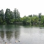
Onumaike Pond is at the foot of Mt. Shigayama, with an altitude of 2,035m, which is located deep in the mountains of Shigakogen Highland in Yamanouchi Town, Nagano Prefecture. The lake water is dammed by the lava flow of Mt. Shigayama. It is highly transparent and shines cobalt blue.
On the lakeside, flowers of Japanese mustard spinach and Hiogiayame, an original species of iris, sways in the wind. On the mountain trails, the virgin forest of Maries’ fir grows. The Highland is the reservoir of nature. You can also enjoy the feeling of highbrow sightseeing, far away from the city.

This area is a scenic spot, mentioned in the railway song, “The best view of the sea in Japan is Gamagori”. A western-style inn and attached Japanese style restaurant, Tokiwa House, was built in a perfect location, on the opposite shore of Takeshima Island, at the end of the Meiji period (1868 – 1912). From here, you can only see Takeshima Island and the blue sea. Many writers and artists visited here who was attracted by the extraordinary view and weaved into their work the rustic beauty of the the sea in Gamagori and Takeshima Island.
This memorial hall presents and introduces literary people and writers, who received the writing and drawing power from Takeshima Island. Takeshima Island, a 680m granitic island, is connected to the land by the Takeshima-bashi, the bridge of Enmusubi, a match-maker. The vegetation of trees in this island is different from the opposite shore, with over 200 species of plants.
This gorge is located at the upper reaches of the Tado River, which flows from Mt. Tado, with an altitude of 403m, at the prefectural border of Mie and Gifu. You can enjoy the colorful seasons with fresh green in spring and autumn leaves.
Near the Midorigaike pond, the natural monument “Inunashi,” the ancestor of a pear, grows naturally and blooms in the middle of April. Genji fireflies, Luciola cruciate, appears in the middle of June.
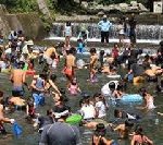
And in the summer, Tado Gorge becomes a natural pool! It has a depth of 80 cm and a water temperature of 20 degrees, and is a dam of the Tado River.
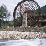
A huge water wheel, with a diameter of 18.18m is located at the upper reach of the Banjogawa River, which is one of the clearest streams in Kyushu Island. There were many water wheels that were used as a power source for agricultural work.
Now, only this huge water wheel is reproduced at the campsite in this park, fits well with the scene of nature, and creates a rhythm. And this rhythm lives with nature.
It gives new ties, when you visit this campsite and spend time.
The mysterious gorges endlessly extend to the upper stream of the Yufugawa River. Kinrin Lake is at the foot of Mt. Yufudake, where the hot springs and clear water springs come together, from the bottom, which is the head of the Oita River. It is famous for the morning mist. A Torii, a gateway at the entrance to a Shrine, floats on the fantastic lake where steam rises. The surface of the lake changes color, part by part, and you can see a beautiful Konara oak, a virgin forest, behind the lake.
There is a history of Busanji Temple, which enshrines Susano-no-Mikoto, the younger brother of Amaterasu Oomikami: Sun Goddess and the Japanese Emperors are considered to be direct descendants of Amaterasu, and a local deity linked with harvest and agriculture.
Susano-no-Mikoto has the extermination legend of a large snake (- In Japan, a large snake used to be the symbol of the lava flow from an active volcano). And Busanji Temple is the guardian deity of Mt. Yufudake.
This park is the famous spot for autumn colors in Saga Prefecture, between Furuyu Onsen, hot spring, and Kumanokawa Onsen.
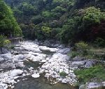
Mt.Tenzan, with an altitude of 1,046m, belongs to the Tsukushi Mountains on the southern end. Mt. Sefurisan, at 1,055m, is adjacent to Fukuoka Prefecture at the northern end. Mt. Tenzan and Mt. Sefurisan link and supply a rich clear stream, which made the beauty of this Gorge through the power of erosion.
Thickly growing trees and beautiful, strangely shaped rocks, and mysterious caves, are enhanced by the vermilion-painted Narusebashi Bridge, which is like Akaetsuke, a porcelain decorated in a colorful over-glazed design.
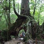
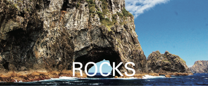
Ryukyu arc is approximately 1,260 km off the coast of Kyushu Island in the Japanese archipelago, such as the Nansei Islands and the Ryukyu Archipelago, where 199 islands dot like the edge of flower. The Ryukyu Arc has tall forested islands and flat islands with clear water springs. Yakushima is a tall forested island.
Shiratani Unsuikyo Ravine is in the branch of the Miyanoura River, floating in the northern part of the island. It was formed from eroding granite from the rich rains and is covered by virgin forest.
The scenery is the original landscape in the Japanese archipelago, from the Jomon period (16,000 years ago – 3,000 years ago).